La Niña conditions in the Pacific fading, may lead to a rise in global temperatures, say experts

It’s too early to call it a summer but some places in India are already on the boil. Angul and Bhubaneswar in Odisha, for example, crossed the 40 degree Celsius mark in February 2021. Mountain states of Uttarakhand and Himachal Pradesh experienced temperatures higher than normal even in January — the time of the year usually characterised by biting cold.
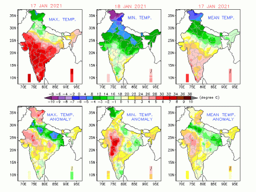
The maximum temperatures soared 5-7 °C above the normal in Odisha, Chhattisgarh and Jharkhand on January 9, according to data from the India Meteorological Department (IMD).
On January 10, the minimum temperatures were even more anomalous with large parts of Uttar Pradesh, Madhya Pradesh, Chhattisgarh, Bihar, Jharkhand and Maharashtra, where night-time temperatures were at least 5°C or more above the average.
Temperature anomalies, January 9, 2021

The IMD, in a March 1 press release, said most of the north, north-west and north-east India, along with a few parts of central India and coastal areas of north Peninsular India, may experience above normal day-time temperatures from March till May.
South India and some parts of central India may see lower than normal day temperatures, the release added.
Warming La Niña
The overarching question is: What disrupted the weather pattern?
The La Niña years may be getting warmer than El Niño events of the past, experts have pointed out.
La Niña is the cooling phase of the El Niño Southern Oscillation cycle in the equatorial Pacific Ocean; El Niño, on the contrary, is the warming phase. It is characterised by the unusual cooling of the central and east-central equatorial Pacific Ocean. It usually brings in colder than normal winters in India.
The current La Niña conditions commenced in October 2020, but have not led to much cooling over India. The IMD has predicted that the moderate La Niña conditions over the equatorial Pacific Ocean will continue through May. La Niña could be bringing warmer air from the North into India, according to Raghu Murtugudde, climate scientist at the University of Maryland.
He said:
“All of Eurasia is also warmer than normal and the La Niña winter pattern is bringing warmth to India as well. The Indian Ocean is much warmer than usual; the Arabian Sea is slightly warmer than usual. So whatever the wind pattern shifts, it seems like warm air is being adverted in.”
Roxy Mathew Koll, climate scientist at the Indian Institute of Tropical Meteorology, Pune said:
“The La Niña conditions in the Pacific are fading, and global agencies forecast that the temperatures will return to neutral and then warm up in the coming months. Hence global temperatures might also rise further in the coming months.”
“Rising temperatures are normal in the time we are living in. Each year and month is warmer than the earlier one,” he added.
That February 2021 was the warmest month in the recorded history is proof enough, Koll said.
He added that 2020 was one of the warmest years despite a La Niña with cool waters in the east Pacific. “The same was observed from January to February, when La Niña was fading from the Pacific. La Niña typically has a cooling effect on global temperatures, but this is now offset by global warming due to greenhouse gas emissions.”
Temperatures in India have been higher than normal through most of January and February. Climate change induced by human greenhouse gas emissions may have had a role to play.
Analysing temperature data from January 17, February 21 and February 28, Down To Earth found that 10 Indian states and Union territories witnessed maximum temperatures deviations of 5°C or more on these days. These were distributed across north, east, central and western India. On February 21, Jammu and Kashmir witnessed a spike of 10°C in its day-time temperatures.
Temperature anomalies


“Large-scale atmospheric processes influenced the weather in India in January and February, leading to extreme anomalies,” said Elena Surovyatkina, climate scientist at Potsdam Institute for Climate Impact Research in Germany.
In North India, the weather disruptions were observed because of two cold air invasions in the first and last week of January. After that they were triggered by recovery and deviation to warmer temperatures.
On February 28, Surovyatkina said, the “clouds banded over the Indian Ocean within the Intertropical Convergence Zone, became denser, shifted to the South and granted India a clear sky.”
She added: “An anti-cyclone over the land dominated over the country, which led to higher maximum temperatures and extreme daily temperature variations. There is no doubt that anthropogenic GHG emissions have contributed to increasing temperatures.”
We are a voice to you; you have been a support to us. Together we build journalism that is independent, credible and fearless. You can further help us by making a donation. This will mean a lot for our ability to bring you news, perspectives and analysis from the ground so that we can make change together.

.png)
Comments are moderated and will be published only after the site moderator’s approval. Please use a genuine email ID and provide your name. Selected comments may also be used in the ‘Letters’ section of the Down To Earth print edition.