
Expert says steering winds may take Mocha towards Myanmar but rapid intensification can trigger high rainfall on the Indian coast


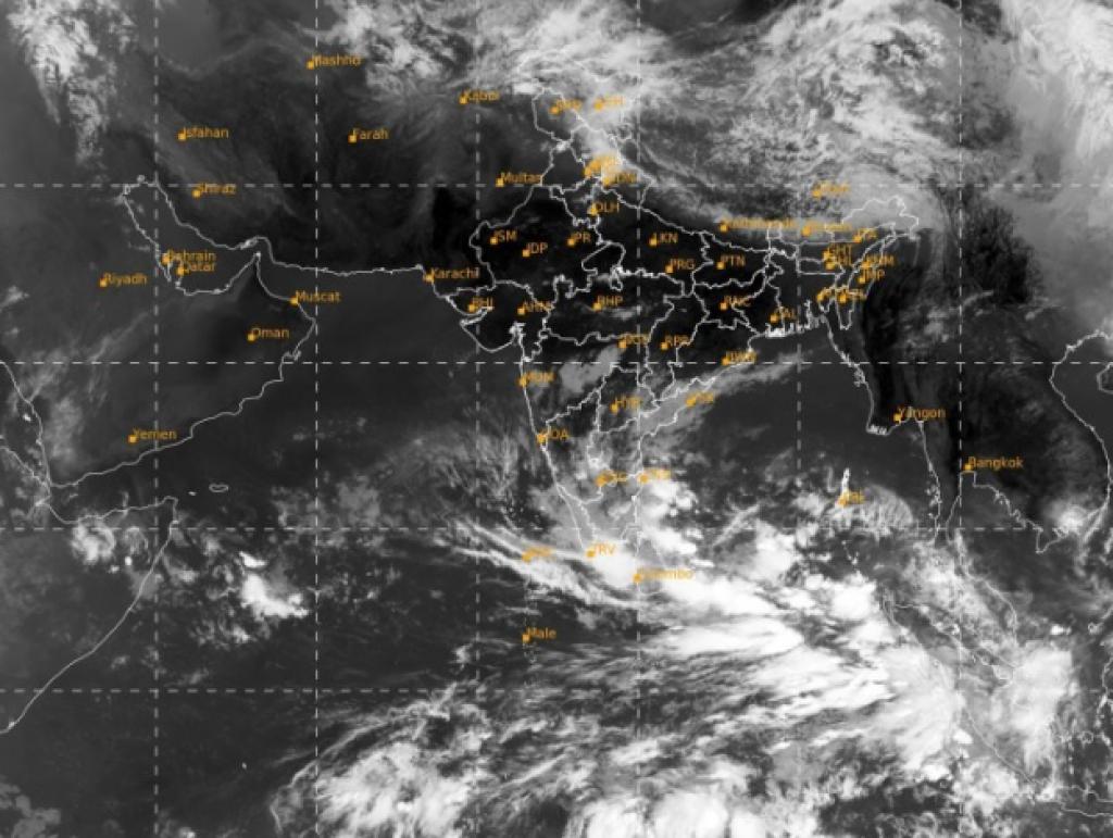
 Satellite image released by India Meteorological Department on May 7
Cyclone Mocha is likely to spare the coast of eastern India and even that of Bangladesh and may make landfall in Myanmar as a ‘severe cyclone’ between May 13 evening and May 14 noon.
Most models highlighted in the Tropical Cyclone Outlook report released by India Meteorological Department (IMD) on May 7 predicted this outcome.
A frontline weather expert also told this reporter that steering winds are likely to take Mocha towards Myanmar. But he added that there may be rapid intensification of the cyclone during intense warming in the region, causing widespread rain on the coasts of West Bengal and Odisha.
IMD however officially only confirmed on May 7 afternoon that:
…cyclonic circulation over southeast Bay of Bengal lay over southeast Bay of Bengal and adjoining South Andaman Sea at 0830 IST of today the 7th May, 2023. Under its influence, a low-pressure area is likely to form over the same region on 8th May … to intensify into a depression around 9th May (and) thereafter … is likely to intensify into a cyclonic storm while moving nearly northwards towards central Bay of Bengal and adjoining north Andaman Sea.
IMD officially continues to state that “the details of its path and intensification will be provided after the formation of the low-pressure area”.
But the models it mentioned in its report give broad clues about the possible path of the cyclone and landfall destinations.
The IMD report released on May 7 points that “there is large variation among various models with respect to time of genesis with IMD GFS indicating depression around May 8th, NCEP GFS on May 9th & ECMWF around May 11th”.
But the report also shares that all these models are “indicating intensification of this system into a severe cyclonic storm”.
It also states that “with respect to track, variation continues among these models with landfall point varying between 16.0/94.8 (GFS) and 17.0/94.9 (ECMWF) during 13th/1200 UTC to 14th/ 0600 UTC”, basically meaning the landfall is set to occur at south to northeastern part of Myanmar between evening of May 13 and noon of May 14.
The earlier predictions had indicated the landfall time to be between May 12 and 13.
“As per most models, the cyclone is likely to make landfall in Myanmar and we have not issued any landfall warning for any Indian coast,” Mrutyunjoy Mohapatra, the director-general of IMD told this reporter on May 6 while cautioning that nothing concrete should be concluded till the low-pressure area is formed.
“The report you mention, is not only for India but for several countries in the region and models only refer to the possibility. Actual interpretation is only possible when the low-pressure area will be formed. We are issuing the communiques so early only to ensure fishermen can return safely from the high seas or do not venture out during the period,” added Mohapatra.
Raghu Murtugudde, an earth system scientist from Indian Institute of Technology Mumbai and University of Maryland, United States also accepts that the Indian coast is likely to be spared and Myanmar seems to be the destination of the landfall.
“We have to wait for the low-pressure formation but the models indicate that Myanmar is the likely landfall point with the steering wind expected to take the system in that direction. The West Bengal and Odisha coasts will be spared,” he told this reporter.
Low to mid-level winds in the atmosphere are considered steering winds. They dictate the direction of a weather system.
Murtugudde, however, said “the point of concern is Myanmar may not be as equipped as Indian states to combat cyclonic impacts”.
“But the thing to watch out for is the possibility of rapid intensification of the cyclone as since March there has been a lot of heat in the zone. In that case, the cyclone may turn stronger and reach higher categories. As a result, despite landfall in Myanmar, the Indian coastal areas may receive significant rain during the period,” he added.
The IMD report admitted that “a trough is also seen near 94º E (east) up to 6º N (north) … (that) indicates strengthening of system” and mentioned that “sea surface temperature (SST) is around 30-32°C over entire BOB (Bay of Bengal)”.
We are a voice to you; you have been a support to us. Together we build journalism that is independent, credible and fearless. You can further help us by making a donation. This will mean a lot for our ability to bring you news, perspectives and analysis from the ground so that we can make change together.

Comments are moderated and will be published only after the site moderator’s approval. Please use a genuine email ID and provide your name. Selected comments may also be used in the ‘Letters’ section of the Down To Earth print edition.