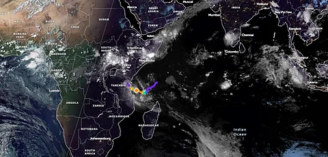

Cyclone ‘Hidaya’ (‘Guidance’ in Arabic and ‘Gift’ in Swahili), a severe storm, is expected to slam into the Tanzanian coast south of Dar es Salaam from the Indian Ocean on May 4, 2024, according to Tanzania Meteorological Authority (TMA).
Even more worryingly, Kenya, which has never seen a cyclone before, may witness one now, President William Ruto announced on May 3 at the State House in Nairobi, while putting East Africa’s largest economy on high alert.
The cyclone comes even as three countries in East Africa have witnessed flood havoc since March this year. Property has been destroyed and 350 people have died so far in the floods that have taken place in Kenya, Tanzania and Burundi.
Cyclone Hidaya is said to have developed over the South Indian Ocean, east of Tanzania and north-northeast of the Comoros, an archipelago in the Indian Ocean. It was designated the name ‘Hidaya’ by the French meteorlogical service, Meteo France’s centre in the Indian Ocean French Overseas Department of La Reunion, according to Citizen Digital, a Kenyan media outlet.
“The storm is currently at a severe level of warning, with maximum significant wave height reaching 7.9 metres (26 feet), and is forecast to make landfall tomorrow. It is predicted to intensify to a peak intensity of 165 km/h (90 knots) in around 24 hours as the environment remains conducive with high moisture content. Anticipated periods of heavy rain and strong winds in Mtwara, Lindi, and Pwani (including the Mafia Islands), according to TMA,” the IGAD Climate Prediction and Applications Centre or ICPAC, posted on its X (Formerly Twitter) account on May 3.
ICPAC is a climate centre accredited by the World Meteorological Organization that provides climate services to 11 East African Countries.
The TMA noted that Hidaya was stationed about 342 kilometres off the coast of the port town of Mtwara in southern Tanzania “until three o’clock in the morning of May 3”. “During this period, typhoon HIDAYA has continued to strengthen with wind speed increasing up to 140 kilometres per hour,” it added.
Hidaya will decrease in strength in the next 12 hours as it continues to move very close to the coast of Tanzania. It is expected to continue to exist until May 5 and will decrease in strength after that, said the Authority.
There will be heavy rain and strong winds in some areas of the regions of Mtwara, Lindi, Pwani, Dar es Salaam, Tanga, Morogoro, the islands of Unguja and Pemba and neighbouring areas.
“Periods of rain and strong winds exceeding 40 kilometres per hour have already started appearing in the areas of Lindi and Mtwara until 9 o'clock this afternoon,” according to TMA.
As the storm weakens, heavy rain and strong winds is expected in other areas of the coast towards May 4-5, 2024.
Meanwhile, Kenya, which is reeling from the effects of floods in recent days and weeks, is bracing for Hidaya.
Kenya is largely considered to be safe from cyclones. Tropical cyclones usually develop at latitudes between 5° and 30° North or 5° and 30° South of the equator in tropical oceans, noted Kenyan state broadcaster, Kenya Broadcasting Corporation (KBC).
“They do not form within 5° of the equator… In the case of Kenya, the country lies within Latitude 4° North and South hence it is safe from Tropical Cyclones,” KBC added.
But Ruto said this may no longer be true.
“Sadly, we have not seen the last of this perilous period, as the situation is expected to escalate. Meteorological reports paint a dire picture. Kenya may face its first-ever cyclone,” news agency AFP quoted Ruto as saying in his address to the nations.
“We have adopted a whole-of-government approach to ensure an effective response to the flood crisis. With meteorological reports forecasting increased rainfall, we urge Kenyans in flood-prone areas to promptly relocate to safer grounds. Adequate resources have been allocated to mitigate the effects of the floods on those affected,” Ruto added.
The Department of Meteorology at the University of Reading in the United Kingdom posted on it X account: “Tropical Cyclone #Hidaya approaches #Tanzania, rare but not unprecedented for such a storm to make landfall so far north in East #Africa.”
Meanwhile, the United States Embassy in Kenya has warned its citizens about the coming cyclone.
“The remnants of Indian Ocean Cyclone Hidaya are predicted to impact Kenya in the coming days. Meteorological reports indicate that very heavy rains will affect central Kenya, including Nairobi, beginning Sunday, May 5th. The coastal region will likely experience strong rains, winds, and tidal swells. Kenyan President Ruto has ordered mandatory evacuations for those located near dams and in flood-prone areas across the country due to recent heavy rainfalls. Expect possible flooding, road closures, and dangerous boating conditions,” it said.