
Subscribe

A major icefield spanning the United States' Alaska and Canada's British Columbia could reach an irreversible tipping point sooner than predicted, with its glaciers rapidly receding since 2005, according to a new study.
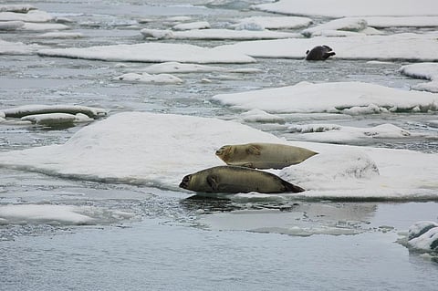
The research, published in Nature Communications, focused on the Juneau Icefield in Alaska. This plateau icefield comprised 1,050 glaciers in 2019, covering an area of 3,816.3 square kilometres. The study found that glacier shrinkage from 2015 to 2019 was five times faster than between 1948 and 1979.
“We know that glaciers in Alaska are contributing substantially to sea level rise — the most from any glacierised region,” said Bethan Davies, Senior Lecturer at Newcastle University and lead author of the study, speaking to Down To Earth.
Alaska's large icefields contain enough glacial ice to raise global sea levels by 46.4 millimetres if melted. Around 25 per cent of global glacier ice loss comes from Alaskan glaciers, which have lost about 66.7 billion tonnes of ice each year. At this rate, all Alaskan ice could disappear in about 250 years, the researchers warned.
Davies noted that glacier mass loss in Alaska is accelerating, but scientists lack a longer-term timeframe to determine the full extent of this trend. To address this, Davies and her colleagues from the United States and Europe studied the long-term response of glaciers to climate change, aiming to understand the acceleration rate of glacier mass loss and the processes amplifying this melt. This knowledge will improve our ability to predict how icefields might respond to future climate change.
The team set out to determine the rates of icefield-wide shrinkage and thinning to quantify glacier change from the "Little Ice Age" (a period of widespread cooling that lasted from 1303 to 1850) to recent times (2020). The reconstructed Little Ice Age revealed that the icefield covered 5,414.95 square kilometres of land, about 30 per cent larger than in 2019. From 1770 to 2013, glacier volume loss was 0.4 cubic kilometres per year.
Between 1770 and 2019, 108 glaciers disappeared, and 100 per cent of the glaciers mapped in 2019 had receded compared to their Little Ice Age positions. This loss coincided with an increase in temperatures, which rose by 1.39°C at Juneau Airport from 1941 to 2020, with a notable shift in the 1970s.
The researchers linked this temperature rise to a shift to predominantly positive values in the Pacific Decadal Oscillation (PDO) from 1976. The PDO is a long-term ocean fluctuation in the Pacific Ocean, which alternates between warm and cool phases approximately every 20 to 30 years. The positive PDO values brought increased precipitation and warmer temperatures to Alaska and Juneau.
Between 1948 and 1979, glacier volume loss was 1.0 cubic kilometres per year, rising to 3.7 cubic kilometres per year from 1979 to 2000. Temperatures remained relatively stable from 1990 to 2005, as did icefield thinning and area loss. However, from 2010 to 2020, the region experienced another temperature rise.
Glacier volume loss increased from 3.1 cubic kilometres per year from 2000 to 2010, to 5.9 cubic kilometres per year from 2010 to 2020. “Alaskan icefields — which are predominantly flat, plateau icefields — are particularly vulnerable to accelerated melt as the climate warms since ice loss happens across the whole surface, meaning a much greater area is affected,” Davies said in a statement.
One significant factor in glacier volume loss is the rising Equilibrium Line Altitude (ELA), the zone on a glacier where snow and ice accumulation balance out with loss over a year. As summers lengthen and winters shorten, and temperatures rise, the height at which snow remains all year round is increasing.
“The flat plateau area was previously above the ELA, with snow remaining year-round. Now, with melt occurring on the plateau, the snowline is on the plateau itself in particularly warm summers. Because the plateau is very flat, a small rise in the ELA exposes a much greater area to melt, accelerating icefield mass loss,” Davies explained.
The team hopes to examine even longer-term records of icefield change, especially through previous periods of rapid climate change, such as during the last glacial-interglacial transition 19,000 to 11,000 years ago.
