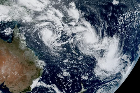

Satellite imagery has revealed a rare meteorological event in the south Pacific Ocean, with three tropical cyclones being simultaneously active in the region.
The cyclones, named Rae, Seru, and Alfred, developed within a span of five days and are currently swirling in waters off the eastern coast of Australia and extending approximately 8,000 kilometres into the Pacific Ocean.
This activity coincides with the peak of the region’s cyclone season.
“This is undoubtedly a very active period for the South Pacific, and having three tropical cyclones at once is quite significant,” Brian Tang, a professor of atmospheric science at the University at Albany told the press. He noted, however, that such an event is not without precedent.
The last instance of three tropical cyclones occurring simultaneously in the South Pacific was in January 2021, when cyclones Lucas, Ana, and Bina were active at the same time, Tang explained.
Residents of Queensland, in northern Australia, are closely monitoring the trajectory of Cyclone Alfred, which formed on Monday and rapidly intensified to a Category 3 storm overnight. With wind gusts reaching 185 km/h in the Coral Sea, there is uncertainty over whether the storm will shift towards the coast and make landfall.
Cyclone Rae, which developed north of Fiji on Friday, has already caused significant damage, with strong winds and heavy rainfall destroying fruit trees, according to local reports. Meanwhile, Cyclone Seru, which reached cyclone strength on Tuesday, is predicted to pass near Vanuatu but is expected to remain offshore.
The climate crisis is playing a role in intensifying such weather events, as rising ocean temperatures provide additional energy for tropical storms. The year 2024 has already recorded the highest ocean temperatures in history.
While global warming is not increasing the overall number of storms, it is contributing to a rise in the frequency and intensity of higher-category cyclones. Research also suggests that these storms are moving more slowly over land, increasing their potential for destruction.
The occurrence of three such storms simultaneously is especially unusual this season, as the planet is currently experiencing a La Niña phase. This climate phase cools ocean temperatures, reducing the energy available to fuel tropical storms. As a result, scientists had predicted fewer than average tropical cyclones for the region this year.
Gabriel Vecchi, a climate scientist at Princeton University, pointed to the presence of a phenomenon known as the Madden-Julian Oscillation (MJO). This atmospheric fluctuation creates a zone of rising air and increased rainfall that moves around the globe, lasting for 30 days or more. Vecchi explained that the MJO appears to be moving across the south-western Pacific in a manner that could amplify cyclone activity.
“The atmosphere is inherently chaotic, with significant natural variability. We must remain open to the possibility that factors beyond our current predictive capabilities may have contributed to the simultaneous formation of these three cyclones,” Vecchi was quoted in a news report.
This rare event highlights the complexity of atmospheric systems and the challenges in forecasting extreme weather patterns, even as scientists continue to study the interplay between natural fluctuations and broader climate trends.