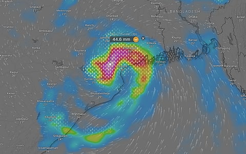

Cyclone Dana, that formed in the early morning hours of October 23, is going to make landfall as a severe cyclone along the Odisha coast near Bhitarkanika National Park and Dhamra port, according to the India Meteorological Department (IMD) and may bring fierce winds, high storm surges and torrential rains to Odisha and West Bengal.
Cyclone Dana is the third cyclone to form in the North Indian Ocean region and the second to make landfall along the Indian coast in 2024. It is the first cyclone in the post monsoon cyclone season.
The peak wind speeds expected would be between 100 and 110 kilometres per hour, with gusts of upto 120 km/hr and storm surge of 0.5-2 m above the astronomical tide along many coastal districts of Odisha and two districts of West Bengal and intense rainfall over many parts of Odisha and West Bengal.
IMD is predicting peak wind speeds from the cyclone in north Odisha and Purba Medinipur district of West Bengal. The strongest winds of the storm are in the northern sector of the cyclone, according to IMD.
Storm surge is the increase in the level of sea tides due to the force of the winds of a tropical cyclone and generally leads to inundation of low-lying coastal areas and incursion of sea water inland, which can have long term impacts on fresh water sources and agriculture of an area.
IMD has predicted the maximum storm surge of 1-2 m in Kendrapara, Bhadrak and Balasore districts of Odisha and Purba Medinipur district of West Bengal. The weather agency has predicted a storm surge of 0.5-1 m in South 24 Parganas district of West Bengal and Jagatsinghpur district of Odisha.
There are many meteorological characteristics of Cyclone Dana which point towards the intense rainfall it may be carrying.
In its tropical weather outlook, IMD highlighted that the cyclone is carrying intense convection in its western sector and the convection is right up to the upper layers of the atmosphere.
There is also warm moist air moving into the core of the cyclone. This may increase convection and hence the rainfall it may carry, according to IMD.
Another factor which may influence the rainfall for Cyclone Dana is the Madden Julien Oscillation (MJO) which is a pulsating band of clouds, storms and rains along the equator. When the MJO is in certain phases, it can enhance rainfall over India. IMD points out that the MJO is in phase 5 for the next five days, which is conducive for convection hence rainfall.
Due to the above factors, IMD has indicated extremely heavy rainfall of more than 210 mm at isolated places in Baleshwar (Balasore), Mayurbhanj, Bhadrak, Kendrapara, Jagatsingpur, Kendujhar, Jajpur, Cuttack, Dhenkanal, Khorda and Puri districts of Odisha on October 24 and 25.
Extremely heavy rainfall at isolated places is also expected over South and North 24 Parganas, Purba and Paschim Medinipur, Jhargram, Howrah, Hooghly, Kolkata and Bankura districts of West Bengal on October 24 and October 25.
Rainfall rate of around 45 mm every three hours is expected over many districts of Odisha, according to the weather analysis and visualisation platform Windy. Such intense rainfall may lead to flash flooding in rivers, which has also been indicated by the IMD in its press release of October 23.