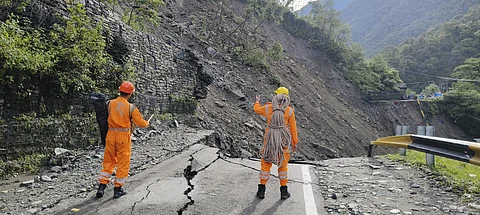

Experts have told Down To Earth (DTE) that the heavy rainfall which caused destruction and damage in several parts of Uttarakhand on July 31 cannot be categorised as ‘cloudburst’. However, it definitely shows the imprint of climate change and highlights that the Indian Himalayas are not prepared to handle so much rainfall.
The districts of Rudraprayag, Dehradun, Pauri and Tehri Garhwal reported instances of damage to life and property due to heavy rainfall on July 31.
The state recorded 145 per cent more rainfall than normal from 08:30 am on July 31 to 08:30 am on August 1, according to the India Meteorological Department (IMD). The state’s two regions of Garhwal and Kumaon received rainfall ranging from 40 to 242 millimetres (mm) on July 31.
Rudraprayag district, where the Kedar Valley is located, received 16 per cent more rainfall than normal. Rain was very heavy in certain areas The weather station at Jakholi, about 78 kilometres from Gaurikund, recorded 59 mm of rainfall. Two locations in Dehradun recorded 242 mm and 210 mm rainfall.
But experts refused to call these instances as ‘cloudbursts’.
According to Rohit Thapliyal, IMD meteorologist, more than 100 mm in one hour is defined as a ‘cloudburst’. In this sense, there has been no cloudburst in Kedarnath. Nainital and Dehradun recorded over 50 mm in one hour. Sonprayag received more than 30 mm of rain in an hour.
Thapliyal said in the sensitive geomorphological conditions of high mountain areas, even less rainfall causes more damage. Landslides occur due to the steep slope and shape of the land and the nature of the soil. This causes extensive damage.
Changing rainfall patterns reflect the risks of climate change. JC Kuniyal, president of the Centre for Environmental Assessment and Climate Change at GB Pant Institute, Almora, said, “Damage has increased due to heavy rains in a short period of time in hilly areas. The Kedar Valley is made up of glacial sediments (debris). Due to the steep slopes, rain water moves quickly. Also, when water fills between the rocks beyond their capacity, they break. Along with all this, micro climate conditions also have an impact.”
“With the rise in tourism in the Kedarnath region, increase in the number of vehicles and in human activities, the local spike in temperature cannot be ignored,” Kuniyal added.
The damage caused in Kedarnath due to July 31’s rain reminded people of the 2013 disaster. Kedarnath is at an altitude of 3,583 metres above sea level. Whereas Gaurikund is 16 kilometers before Kedarnath, at an altitude of 1,982 metres.
DP Dobhal, a retired glacier scientist from Wadia Geology Institute, said the possibility of cloudburst at Kedarnath’s height is negligible. There was no cloudburst incident in 2013 as well. Even then, water levels in rivers had increased due to continuous heavy rains and bursting of glacial lakes.
With the shortening of winter and increasing duration of summer, both the range and intensity of rainfall has increased. It is now raining even in areas where it used to snow earlier.
“Earlier there used to be very scanty rain around Kedarnath. But now, the sensitive topography of this region is bearing the brunt of heavy rains,” said Dobhal.
Heavy rain in the mountains is also increasing the risk of loss of life and property. Manish Mehta, scientist at the Wadia Institute of Geology, is preparing to go to Ladakh to study the impact of seasonal changes on glaciers.
He said, “The geologically-young Himalayan range is not built for heavy rainfall. It should drizzle here. We can call this the effect of climate change that the intensity of both heat and rain is increasing in the mountains.”