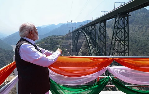

On June 6, 2025, Prime Minister Narendra Modi flagged off the Katra-Srinagar Vande Bharat Express and inaugurated an alternative all-weather transportation system between the Kashmir Valley and the rest of the country.
The Udhampur-Srinagar-Baramulla rail link has now been connected with the national railway network and will offer connectivity between the Valley and other states.
Completing the rail link has been a Herculean task, especially the Chenab bridge, the highest rail bridge in the world.
Kashmir, a valley located between the Greater Himalayan Range and the Pir Panjal range, has always been a challenge for travelers. However, a chain of mountain passes linked the Valley with the outside world, providing a lifeline for its people and for the transit of goods.
One of the earliest references about travelling to Kashmir comes from the Ain-e-Akbari of Akbar’s faithful courtier, Abul Fazl.
He describes how the Valley is surrounded on all sides by high mountains and adds: “Twenty-six different roads lead into Hindustan but those by Bhimbar and Pakli are the best and are generally practicable on horseback. The first mentioned is the nearest and it has several routes of which three are good, viz., (1) Hasti Bhanj which was the former route for the march of troops; (2) Pir Panjal, which His Majesty has thrice traversed on his way to the rose garden of Kashmir. If on these hills an ox or a horse be killed, storm clouds and wind arise with a fall of snow and rain; (3) Tangtala.”
In 1586 CE, Emperor Akbar conquered Kashmir and incorporated it into the Mughal Empire. Kashmir was a ‘sarkar’ (district) under the subah of Kabul. Prior to the Mughal conquest, Kashmir had been ruled by Hindu and Buddhist monarchs as well as Muslim Sultans. Akbar conquered Kashmir after defeating the Chak Sultanate of the Valley (1561 to 1589).
Colonel H S Jarett’s translation of the Ain also carries a foot note which further describes the routes to Kashmir.
“Three different routes into Kashmir are thus described. The first runs almost in a straight line passing through Noushera, Rajouri, the Pir Panjal pass and Shupiyan. The second deviating from Rajouri to the Punch river and on to Punch and crossing the Haji Pir, joins the Murree road near Uri. The third, parting from Samani Sarai, passes through Kotli and Sera to Punch and unites with the second. The route by Shupiyan is the Pir Panjal. The second is Tangtala which name, however, is no longer known and is probably a misscript. The third is believed to be the Hasti Bhanj, for it is the only one by which elephants can travel,” it says.
Abdul Majid Mattoo, in his Subah of Kashmir under the Mughals: With Special reference to society and administration, notes that after the conquest and incorporation of Kashmir as a Sarkar of the Empire, the Mughals set about expanding and maintain the routes to access the Vale.
“Surrounded by an unbroken chain of high mountains Kashmir was physically hampered to keep pace with the economic development of the rest of the Empire. Trade and commerce could not flourish on account of these natural restraints. But this ring of mountains was pierced by various passes which established links with the outside world and ensured the needs of the land being fulfilled by contacts with the people inhabiting other lands. The Mughal occupation enhanced the importance of the Subah, and a regular link was maintained with the rest of the Empire. The routes received extra care and were maintained properly.”
Mattoo adds that “the Mughals paid great attention to the maintenance of these routes. Rivers were spanned with bridges, and inns were built all along to provide shelter to the travellers. These steps gave a fillip to the trade and commerce of the Subah.”