
Subscribe

The Western Himalayan region, stretching from Dharali in Uttarakhand to Kishtwar in Jammu and Kashmir, is currently reeling under the devastating impact of natural disasters such as flash floods, cloudbursts, and landslides. On August 5, the Kheer Gad in Dharali, Uttarkashi, and on August 14, the streams in Chashoti, Kishtwar, brought flash floods that once again highlighted the vulnerability of this region. Himachal Pradesh, situated between these areas, has been continuously enduring nature’s wrath for the past few years. While climate change and human errors are the primary causes of these disasters, little attention is paid to the small tributary streams and rivulets, locally known as gad or gadera. Yet, it is these very streams that wreak havoc. These small water channels, such as Kheer Gad, Birahi Gad, Kanodia Gad, and Assi Ganga, prove far more destructive than larger rivers like the Ganga, Alaknanda, Bhagirathi, and Chenab. Their ferocious nature is not a new phenomenon. From the Alaknanda flood of 1970 to the Bhagirathi flood of 1978, and now the Dharali disaster of 2025, the destructive power of these small streams and rivulets has repeatedly come to the fore. Therefore, it is imperative to study the hydrological system of this region and develop a future disaster mitigation strategy by analysing the entire catchment area of the Himalayas. After all, these gad-gaderas are the very sources of rivers like the Ganga, Yamuna, Sutlej, and Jhelum. These small streams, flowing through narrow valleys and steep slopes, rapidly bring down water and debris, causing flash floods and debris flows.
The Himalayan hydrological system is complex, where climate change, rugged terrain, and human activities give rise to disasters. Large rivers like the Ganga begin at places like Devprayag, but their tributaries, such as the Alaknanda and Bhagirathi, and the smaller gad-gaderas connected to them, are their true water sources. According to a study by the International Climate Research Center, 70-80 per cent of flash floods in the Himalayas are linked to these small streams, which rapidly carry water from heavy rainfall or melting snow in upper regions. Another study analysing the Alaknanda river system using the Soil and Water Assessment Tool model indicates that 20-24 per cent of the water comes from these small streams, amplifying floods. Without studying the entire catchment area, forecasting and prevention become impossible. Expert Anand Sharma, former director of the India Meteorological Department, emphasises that instead of focusing solely on cloudbursts, monitoring rainfall across the entire catchment area is crucial, as these remote small streams are the primary cause of floods.
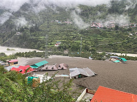
Why do small streams and rivulets cause more damage than larger rivers? The answer lies in a combination of geographical, climatic, and human factors. The narrow valleys and steep slopes of 40 to 50 degrees in the Himalayas accelerate the flow of water and debris. These streams, swollen by heavy rainfall or melting snow, carry soil, rocks, trees, and large boulders downstream, creating debris flow zones. If markets or settlements are located in these zones, as seen in Dharali, the destruction is magnified. Small streams can also temporarily block larger rivers, forming lakes. Currently, near Dharali, debris brought by another stream has created a lake in the Bhagirathi. The bursting of such lakes has historically caused catastrophic floods. For instance, in 1978, Kanodia Gad in Uttarkashi caused a landslide that formed a 30-metre-high temporary dam at Gangnani, which, upon bursting, led to a devastating flood in the Bhagirathi. Climate change increases atmospheric moisture due to rising temperatures, leading to extreme rainfall events. A 2022 study by the Indian Institute of Tropical Meteorology, Pune, confirmed an increase in such events in the Western Himalayas over the past 50 years. Additionally, glacial lake outbursts due to melting glaciers cause flash floods. Human activities, such as unplanned road construction, dams, and deforestation, destabilise slopes in geologically fragile areas. Construction near the Bhagirathi in places like Dharali, located in the Main Central Thrust zone where rocks are fractured, has exacerbated debris flows. The Teesta-III dam in Sikkim, destroyed in 2023, is another example.
Historical examples of these disasters underscore the region’s vulnerability. In August 2025, a flash flood from Kheer Gad in Dharali swept away the market, causing significant loss of life. Kheer Gad pushed the Bhagirathi toward Mukhwa, disrupting the river’s flow. In 1978, Kanodia Gad created a lake at Dabrani, blocking the Bhagirathi, and its breach caused a catastrophic flood. The 1970 Alaknanda flood saw Birahi Gad, Patal Ganga, and other streams bring debris that caused widespread destruction. In February 2021, a rock avalanche and glacial melt in Rishi Ganga and Dhauliganga killed over 200 people and destroyed the Tapkeshwar Hydropower Project. The 2013 Kedarnath tragedy, caused by the bursting of Chorabari Lake and debris from small streams, devastated the Mandakini Valley, claiming over 5,700 lives. In 1998, a flood in Malpa Gad in Pithoragarh killed 221 people. In Kishtwar’s Chashoti, floods from streams on August 14-15, 2025, claimed dozens of lives and washed away villages. Other examples include Assi Ganga (2010), Raunti Gad (Chamoli, 2021, 200 deaths), and Ladakh (2010, 234 deaths).
Mitigating these disasters requires multifaceted measures. Heavy rainfall alerts from the India Meteorological Department, AI-based nowcasting, and an expanded radar network can create effective warning systems. Community-based alerts, such as upstream-downstream warnings on the Ratu river, and cross-border cooperation (China-Nepal model) can save lives. Geological surveys, risk zoning, and strict land-use regulations are essential before development. Construction in debris-flow zones must be banned. Climate-resilient roads, bridges, check dams, and slope stabilisation, along with large-scale afforestation and traditional water harvesting, will provide natural buffers. Building community capacity, insurance, and livelihood diversification will enhance resilience. Integrating defense forces and state governments at the national level and adopting resilience models from countries like Nepal and Bhutan will ensure long-term prevention.
From Dharali to Kishtwar, a comprehensive study of the hydrological system of small streams and rivulets in the Western Himalayas is urgently needed. Emphasis must be placed on watershed management of all rivers and streams. Small check dams on these gad-gaderas will not only reduce the intensity of water flow but also facilitate groundwater recharge, creating new water sources and aiding water conservation. This work can also generate employment for local communities. Additionally, afforestation and advanced warning systems can reduce risks. With government will and investment, these measures can safeguard Himalayan communities.
Jai Singh Rawat is a senior journalist with 47 years of active experience in full-time and freelance journalism. He has authored eight books, two of which have been published by the National Book Trust (NBT) of the Government of India.
Views expressed are the author’s own and don’t necessarily reflect those of Down To Earth