
Subscribe

Hurricane Beryl made its third landfall along the Texas coast on July 8, 2024, killing seven people and leaving around three million people without power. The earliest Category 5 hurricane ever in the North Atlantic Ocean, Beryl has left a trail of devastation along its path from the Caribbean Islands to Mexico’s Yucatan Peninsula and now Texas.
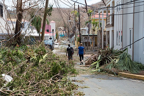
As many as 10 people lost their lives due the hurricane impact in the Carribean islands.
The main destructive features of the storm, apart from the fierce winds, have been the heavy rainfall and strong storm surges that have inundated coastlines.
The hurricane made its first landfall as a category 4 storm system (wind speeds ranging from 209 kilometres per hour to 251 km / hr) in Grenada and also had a major impact on many islands of St Vincent and the Grenadines, all part of the Windward Islands.
In Grenada, around 110,000 people were exposed to the hurricane’s impacts, along with almost 60,000 buildings and 916 km of roads, according to data from the European Union’s Copernicus Climate Change Service (C3S). C3S mapped the areas where Hurricane Beryl tracked and exposed people and infrastructure to its dangerous impacts. Three people lost their lives due to the impacts of the hurricane in Grenada.
In St Vincent, the number of exposed people was 87,000 while the number of exposed buildings and roads were 35,458 and 887 km, respectively. Almost every home on the islands of Mayreau and Union was flattened by the storm, according to media reports. Three people died due to the impacts of the storm.
Beryl moved past the southern coast of Jamaica as a Category 5 hurricane (wind speeds in excess of 252 km / hr) on July 3 but did not hit the island with those wind speeds.
The worst impacts came to the island in the form of coastal flooding from 12 hours of continuous rainfall and storm surges on July 3. A storm surge is the increase in coastal tides due to the wind energy of tropical cyclones.
Along Jamaica’s coasts, there was an increase in water levels of 1.8-2.7 metres above normal tidal levels and rains, totalling 101-202 mm with local extremes of more than 300 mm, according to the World Meteorological Organisation (WMO).
Around 1.1 million people were exposed to flooding and other impacts in Kingston, the capital of Jamaica, along with 8,201 hectares of built-up area, according to C3S.
WMO also highlighted the rapid intensification of Hurricane Beryl from a tropical depression to a major hurricane in a span of 42 hours and that it happened so early in the hurricane season, which runs from June to November.
Usually, the North Atlantic becomes warm enough to support major hurricanes (Category 3 and above) only in August or September but in 2024, such conditions were present in June itself.
“Caribbean ocean heat content today is normally what we get in the middle of September,” according to Philip Klotzbach, in the WMO press release. The region has experienced record-high sea surface temperatures for around 14 months now.
In the coming days, its remnants have been predicted to move north-east bringing rainfall, according to the United States’ National Hurricane Center. The southeastern and northeastern states of the US will be suffering from the impacts of the tropical storm, while the western parts suffer from debilitating heatwaves and wildfires.
“We need to be especially vigilant this year due to near-record ocean heat in the region where Atlantic hurricanes form and the shift to La Nina conditions, which together create the conditions for increased storm formulation,” said Ko Barrett, deputy secretary general of the WMO in a press release.
Early warnings by the WMO community and improved disaster risk management have dramatically reduced fatalities, but Small Island Developing States in the Caribbean still suffer disproportionately, the expert noted. “This is why WMO and its partners have prioritised early warning action in small islands under the international Early Warnings For All initiative,” she added.