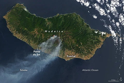

Since last week, the southern part of the Portuguese island of Madeira has been witnessing forest fires that have devastated more than 5,000 hectares of wilderness. The wildfires have posed an existential threat to the largest surviving laurel (Laurus nobilis) forests in the world which are also deemed as a World Heritage Site by the United Nations Educational, Scientific and Cultural Organization (UNESCO).
Madeira is among the most popular tourist spots in the Iberian Peninsula (Spain and Portugal) and dozens of tourists are reported to be stranded on the island battling the fury of forest fires.
According to National Aeronautics and Space Administration (NASA) satellite imagery, the blaze began in the mountains of Serra de Água on August 14 and quickly spread eastwards in the direction of Curral das Freiras and Câmara de Lobos.
“When the OLI (Operational Land Imager) on Landsat 8 acquired these images on August 17, the fire was burning on three active fronts, and smoke streamed from the southern coast of the island over the Atlantic Ocean,” NASA mentioned in its report on the fire.
What has helped the fires spread is the ongoing heat and coastal winds.
In the days after the fire spread, local press reported that wind gusts up to 70 kilometres (43 miles) per hour and temperatures hovering around 30 degrees Celsius aided the fire.
“After August 17, the fire fronts expanded west and north of Serra de Água. On August 18, more than 160 people were evacuated from their homes, local authorities said, as firefighters attempted to tackle the blazes in difficult-to-access hilly terrain,” NASA’s earth observatory noted.
Miguel Albuquerque, president of the regional government of Madeira, was quoted as saying that the fire is burning in remote areas beyond the scope of the residential zones.
“There is no threat to the population, homes, or infrastructure. The intervention so far has been appropriate,” Albuquerque stated.