
Subscribe

The district administration of Bastar in Chhattisgarh, along with non-profit Ashoka Trust for Research in Ecology and the Environment (ATREE), has digitised revenue and forest department maps to ease the process of allotting claims to titles under Community Forest Rights (CFR).
The administration and ATREE have brought the maps together on a webGIS (web-Geographical Information System) platform. CFR titles are claimed under The Scheduled Tribes and Other Traditional Forest Dwellers (Recognition of Forest Rights) Act, 2006.
The administration took the step after realising that local villagers and the revenue and forest departments were not on the same page regarding village and reserved forest boundaries.
Chhattisgarh has granted 3,400 CFR titles in 28 districts through January 2022 of which, 193 were from Bastar district itself.
In a telephonic conversation with Down To Earth, Sharachchandra Lele, distinguished fellow in environmental policy and governance at the Centre for Environment and Development, ATREE said one of the problems faced during filing claims for the titles is the lack of a common understanding of the terrain between villages, the revenue department and the forest department.
Y Giri Rao, noted forest rights activist also said a lack of clarity in maps and overlapping boundaries create disputes and conflicts on the ground whenever a claim is filed.
“When the Gram Sabha of any village needs any document, even maps, from the government, the forest and revenue departments are supposed to provide them with a certified copy of the required documents,” he said.
“But we have seen that sometimes, the two departments do not cooperate. Then, there is another problem of overlapping boundaries. If a village Gram Sabha decides to map the boundaries of the village, they do not even inform the neighbouring villages about overlapping areas. Thus, conflict arises when CFR claims are filed,” he added.
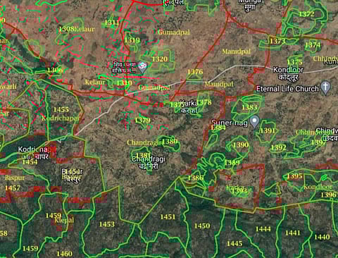
“The initiative to improve the quality of CFR claim-making was taken by the district collector of Bastar himself. He approached ATREE for technical support and input. ATREE’s team proposed (among other measures) the creation of a web-GIS platform where all available maps would be overlaid on a physical picture of the landscape (a satellite image),” Lele said.
Rajat Bansal, the district collector of Bastar told DTE that it was the need of the hour to streamline the process with the help of technology as a lot of disputes kept arising because of a lack of clarity while filing and granting CFR claims.
“The on-field coordination becomes very difficult when the two departments and the villagers are not on the same page. Some of the hamlets are very remote and the villagers do not have proper maps, nor the means to travel back and forth every time there is a dispute regarding boundaries. We have been working in CFR for last two-and-a-half-years and have seen several such cases,” Bansal said.
The team at ATREE designed a public domain web-GIS (web-Geographical Information System) platform, using existing maps and open-source leaflets, to make the CFR claim process more transparent.
“We have sourced the basemaps from Google and Bing satellite images and created layers to show the revenue department and forest compartment boundaries. The basic software can be used for any place, but the one that we have created is specifically for Bastar, using the existing maps of the forest and revenue department and cadastral maps,” Shiva Subramanya, webGIS specialist, ATREE, said.
“New layers can be added to see the village boundaries and forest landscapes on the map at the same time,” he added.
ATREE trained 18 Forest Rights Act coordinators from Bastar district, almost entirely from the Adivasi community, to spread awareness and help with the technical aspects of the platform.
They are working on spreading the word about CFR rights among villagers, communicating with them in local Adivasi languages.
Rao however pointed out that the maps used on the platform were old and may create disputes while filing claims.
“The initiative is commendable and it also reflects the reserved forest boundaries. But the only problem is that the revenue department maps they used are outdated. I think they are from the 2001 census and a lot of changes have happened since,” Rao said.
“The bifurcation of Madhya Pradesh and Chhattisgarh took place in 2000 and since then, a number of new villages have been created, while some others have been merged. So, if the platform does not use the current maps, it may lead to conflicts. It is possible that some villages may not even reflect on the maps they are using,” he added.
Lele acknowledged the problem. He told DTE that since the government itself did not have the latest maps, ATREE had to use those from the 2011 census.
“We are not claiming to be the final authority when it comes to land rights and boundaries. It is an initiative to make things easier by giving the villagers and frontline officials a clearer idea about village and forest boundaries,” he said.
“It does not solve all problems. For instance, out of the 600-odd villages in the district, about 75 have been bifurcated and the forest may be distributed unevenly between them. Villagers will still have to resolve such conflicts on the field. We will, of course, keep updating the layers as and when we get access to the new maps,” Lele added.
Rao said the initiative can be replicated in other states too as it is an India-wide problem.
“This is the biggest problem, countrywide, when dealing with CFR. Other state governments can take inspiration and create the web-GIS for their states as it will make the CFR process simpler and faster,” Rao said.
Lele further told DTE that his team is now working on creating an Android-based GPS app.
The app will not only plot the CFR claims but also display the GPS track on the boundary maps in the web-GIS and allow the village to upload its claimed boundary to the web-GIS.
This is so that these are all visible to the Sub Division Level Committee and District Level Committee, to neighbouring villages and the wider public.