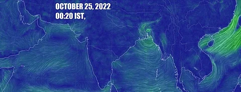
Cyclone Sitrang surprise: Landfall already complete in Bangladesh
Cyclone Sitrang started landfall around 9:00 pm (October 24, 2022) along the Bangladesh coast between Barishal and Chattogram, close to Bhola, according to the latest cyclone update from the Bangladesh Meteorological Department (BMD).
The weather agency predicted the landfall process to take up three-four hours. It said wind speeds around 62 kilometres per hour (kmph), gusting up to 88 kmph were prevailing in the region — within 54 km of the cyclone centre.
European Center for Medium-Range Weather Forecasting data as visualised by the Windy website showed that landfall process had ended as of 11:00 pm, October 24.
The eye of the cyclone was somewhere between Khulna and Barisal, according to the data, and fierce cyclonic winds (above 100 kmph) were prevalent in areas as far off as capital Dhaka. Down To Earth doesn’t have ground observations.
“The low lying areas of the coastal districts of Satkhira, Khulna, Bagherhat, Jhalokathi, Pirojpur, Borguna, Patuakhali, Bhola, Barishal, Laxmipur, Chandpur, Noakhali, Feni, Chattogram, Cox’s Bazar and their off shore islands and chars are likely to be inundated by the wind driven surge height of 5-8 feet above normal astronomical tide,” said BMD in its update.
The track of the cyclone as per ECMWF data on Windy is taking it north eastwards into Meghalaya and into Assam. Earlier the track was more towards Tripura, then Assam and Nagaland.
The system will de intensify as it crosses Bangladesh. But it will definitely bring copious rainfall to all these regions. Bangladesh already suffered from devastating floods in June and then further flash floods during the rest of the monsoon season.
Northeast Indian states, especially Assam and Meghalaya, also suffered from floods in June but things have rather quiet ever since but the floods have now come back in October after the monsoon has already withdrawn from India.
The speed at which Cyclone Sitrang took its last few strides to reach the Bangladesh coast would have taken weather forecasters by surprise. In the afternoon it had been hurtling at a break neck speed of 21 km/hr but IMD had predicted that the landfall would happen early in the morning of October 25.
It has happened at least 9-10 hours before that. The good thing about this speed was that the cyclone did not spend much time on the sea to gain wind speed or rainfall.

