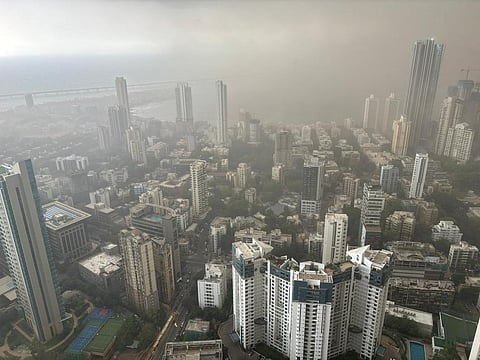

Mumbai on May 13 and Delhi on May 10, separated by 1,500 km, experienced dust storms with extremely high wind speeds. Both the events occurred due to powerful storm systems that were fuelled by fierce external winds.
While two people were killed in Delhi and 23 were injured, 14 people were killed when a billboard collapsed in Mumbai.
There are multiple factors responsible for the formation of dust storms. “The prerequisite factor for the formation of any storm is heating of the land. Usually, heating of 4-5 days is needed for convection to form which develops into a storm,” KJ Ramesh, former director-general of India Meteorological Department (IMD), told Down To Earth (DTE).
“Once the storm forms, it is sometimes piloted by cold and dry downdraft winds that are downward facing and energetic, also aided by gravity. These winds can get very strong when they travel over hot surfaces caused by heating during summers,” said Ramesh.
They precede the actual rainfall and thunder-causing storm and sometimes get added onto the winds of the storm, raise the dust and lead to dust storms, he added.
“The storm that affected Mumbai formed around Igatpuri between Mumbai and Nashik, which is a hilly area. It seemed to be moving in a westerly direction but was suddenly pushed in the southwest direction towards Kalyan and Thane due to the prevailing winds,” Rushikesh Agre, an independent weather forecaster from Pune, told DTE.
The easterly winds were dominant over the normal westerly winds which flow in from the sea, according to Agre. Agre tracked the storm and said the storm system expanded and intensified around Badlapur due to a merger with another storm which was not expected.
“I was taken by surprise by the sudden intensification, as the wind speed recorded at Badlapur was around 107 kilometres per hour and the usual humidity of the region was lacking. It was quite dry at the time when the storm happened,” said Agre. There were quite a few places that recorded wind speeds more than 100 km / hr. The last time Mumbai experienced an intense dust storm was in January 2022.
For Delhi, this was the first dust storm of the season. Dust storms are common events during the summer season for the city and the rest of north and northwest India, but the intensity of the winds was higher than normal this time.
The observatory at Delhi airport recorded a peak wind gust of 92.7 km / hr, according to independent weather forecaster Navdeep Dahiya on the social media platform X (formerly Twitter).
The normal wind speeds during these dust storms are around 40-50 km / hr. During the record-breaking dust storms in 2018, which affected many northern, central and eastern states of India, wind speeds as high as 130 km / hr were recorded at some places.
DTE had reported that the intense and unusual dust storms that killed 423 people and injured 785 were caused by increased western disturbances, heating of northwestern India and the rapid warming of the Arctic region.
The further intensification of the winds that was witnessed in Mumbai and Delhi could also be because of the tunnelling effect caused by winds flowing in cities in valleys between high built up areas, according to Ramesh. In the case of Mumbai, the Western Ghats surrounding the region could have further enhanced the winds. “Tunnelling effect may increase wind speeds by up to 40 per cent during these dust storms,” said Ramesh.
Mumbai locality gripped by fierce dust storm with wind speeds touching 107 km/hr. Photo: Rushikesh Agre
On May 10, there were two cyclonic circulations, one over Iran and the other over northwest Rajasthan, according to IMD. The weather agency predicted that these would induce dust storms over Uttar Pradesh, Haryana, Chandigarh and Delhi between May 10 and May 13 and over Rajasthan during May 10-11.
A cyclonic circulation is a swirl of winds in the lower levels of the atmosphere (troposphere), which is generally responsible for inducing storm systems and causing rainfall. These circulations are often affected by western disturbances coming in from the Mediterranean region over Iran, Afghanistan and Pakistan.
The western disturbances have been active throughout the summer season of 2024, causing unseasonal snowfall and rainfall in the Himalayas.
On May 13, IMD highlighted that a cyclonic circulation was lying over south-interior Karnataka region and a trough (an extended low pressure area) was existing between the circulation and northwest Madhya Pradesh. This could have had an influence on the dust storm in Mumbai.
There were also other factors at play in both places. “An anticyclone is present over the Arabian sea. Winds, thus, become northerly which also became a favourable condition for the dust storm,” said Rushikesh Agre.
“Anticyclones over the Arabian Sea and Bay of Bengal with their clockwise winds are bringing winds on shore all across India right now. These have been causing thunder / dust / hail storms, sometimes with rainfall, in many states in the west, south and east,” said Ramesh.
“More of the winds over Delhi are coming from over upper Pakistan but the winds over Mumbai are sweeping in from the Middle East and lower Pakistan,” Raghu Murtugudde, professor of climate studies at Indian Institute of Technology, Bombay and emeritus professor at University of Maryland, told DTE.
“The anticyclone can bring more moisture or more dust depending on how far north it is. We have to wait and see if a trend is emerging but the Middle East warming and the wind shifts over the Arabian Sea during March-April-May and the Arabian Sea warming are a trend already,” Murtugudde added.