Natural Disasters

India releases first ever national disaster management plan

The plan spells out the roles of all tiers of the government, including panchayats and urban local bodies

 
By Jigyasa Watwani
Published: Thursday 02 June 2016

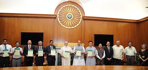
The plan was released by Prime Minister Narendra Modi on June 1, 2016

India’s first disaster management plan in history hopes to “make India disaster resilient, achieve substantial disaster risk reduction and significantly decrease the loss of life, livelihoods and assets.” The plan was released by Prime Minister Narendra Modi on June 1, 2016.

Prepared by the National Disaster Management Authority, the plan spells out the roles of all tiers of the government, including panchayats and urban local bodies. It identifies crucial parts of disaster management such as early warning, information dissemination, medical care, fuel, transportation, search and rescue, evacuation, among others.

The plan is in tandem with the four primary themes of the United Nation’s Sendai framework—understanding disaster risk, managing risk by strengthening governance, investing in disaster risk reduction for resilience and enhancing disaster preparedness. The Sendai Framework 2015-30 is a non-binding agreement endorsed by the UN General Assembly after the World Conference on Disaster Risk Reduction.

The plan ensures that all phases of disaster management—preparedness, mitigation, response and recovery—are covered by a horizontal and vertical integration among all agencies and departments of the government.

The NDMA seeks to improve the plan periodically by keeping up with the knowledge base and global practices in disaster management.

The plan also states that six areas, namely the Himalayas, coastal tracts, riverine areas, the northeast, arid and semi-arid regions, islands and marine assets located in one or more state or union territory, require special attention vis-a-vis disaster management.
 
In the Himalayan region, human activities are the prime cause of environmental degradation. Coastal areas are constantly at risk of geological shoreline changes, cyclones, sea level rise, coastal flooding and tsunamis. Riverine regions, which are primarily dependent on agriculture, are subject to extremes of rainfall conditions. Therefore, they are most vulnerable to riverine flooding and food shocks during droughts.
 
The Northeast needs to be treated in an integrated manner for disaster management. Union territories, islands and marine assets are at risk from multiple hazards such as sea surges, high velocity winds, cyclones, earthquakes and tsunamis. Arid and semi-arid regions require special attention like monitoring of hydro-meteorological and agro-economic conditions as well as accurate forecasting methods.

Subscribe to Daily Newsletter :
Related Stories

India Environment Portal Resources :

Comments are moderated and will be published only after the site moderator’s approval. Please use a genuine email ID and provide your name. Selected comments may also be used in the ‘Letters’ section of the Down To Earth print edition.