
Subscribe
Seventy-nine people have been confirmed as victims after a massive landslide struck a railway construction camp about 75 west of Imphal on the midnight of June 29, 2022.
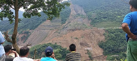
The disaster happened at Marangching village part 5 in Noney district, newly carved from Tamenglong. As of July 4 evening, 47 bodies out of the 79 confirmed victims were recovered while 18 injured persons were rescued and referred to hospitals for treatment.
Of the total bodies recovered, 28 are of Army personnel while 14 others including two Army personnel are still missing.
This reporter, along with two colleagues, trekked two kilometres of hilly terrain in the forest of Charoi Pandongba area in Noney district to reach the Ijai river bank.
About 500 National and State Disaster Response Force and Army personnel as well as local volunteers are engaged in search operations on the other bank since June 30, even as the river is full of debris.
“Body identification has become increasingly difficult due to tissue deterioration,” an official note highlighting the updated figure of the search on its fourth day, said. “Finding missing bodies is also increasingly difficult as our ability to trace those decreases with depth,” it added.
The landslide area covers roughly a one kilometre stretch. This and the inclement weather conditions means the search will take a few days more, according to officials.
Many men and women from nearby villages have visited the disaster site, hoping to witness the recovery of bodies by search parties.
The geological weakness of the soil, lack of vegetation, prolonged human pressure and most importantly incessant rain are the major factors for the landslide having occurred, experts told this reporter.
“Apart from weakness of the soil due to prolonged exposure, rainfall and anthropogenic (human) pressure factors, the way the people used the land is also responsible for this tragedy,” N Deva Singh from the department of geography at Manipur University, Imphal, told this reporter.
Noney district received 348.5mm of rainfall in June. It recorded the highest rainfall in the state for May since 2013, with 257.93 mm rain, according to the directorate of environment and climate change’s daily weather reports.
S Ibotombi from the department of earth sciences at Manipur University said almost all landslides in the hilly states of North East India have been caused due to weak lithology, intense fracturing of rocks, steep slopes, thick mantle of waste and excessive rainfall in short duration.
“In the present slope failure (landslide) of Tupul area (Noney district), what I can say at the moment is that the critically stable slope mass of the area has already been disturbed by construction of other structures,” Ibotombi said.
“In addition, there was incessant rain continuously for a few days before the landslide,” he added. This led to oversaturation of the slope mass exceeding the plastic limit, probably reaching the liquid limit of the soil mass.
Consistency limits such as plastic and liquid limits are index properties of soil which determine whether a soil will be in solid, plastic or liquid states as a function of water / moisture content in soil.
“So the oversaturated and weakened slope mass, nearly reaching the liquid state, failed to resist gravity, leading to this massive landslide in the early hours of June 30,” Ibotombi said. “But the details can be ascertained only after thorough investigations,” he added.
In May this year, incessant rain has triggered a landslide in Tamenglong district, which borders Assam and had cut the road connectivity between Tamenglong and Tamei towns.
Similarly, two highways in Churachandpur district that connect Mizoram and other interior sub-divisions of Manipur have been cut off.
This happened after torrential rain washed away the newly constructed road diversions on National Highway 102B (Guite Road) and National Highway 2 (Tipaimukh Road) during the same month.
Interestingly another researcher here observed that the recent incident could be because of multiple effects. These include major earthquakes of 6.7 magnitude on the Ritcher scale in the nearby areas in 2016, incessant rainfall, toe cutting by river and subsequent railway yard cutting, etc.
A senior official of the Manipur Remote Sensing Application Centre in Imphal said there were sufficient earlier records that termed Manipur as being prone to floods, landslides, earthquakes and cyclones.
The official expressed the need to conduct a detailed study to find out high risk zones in the state.
In August 2015, 20 people died in a landslide caused by heavy rain in the Joumol village of Manipur's Chandel district. In July 2017, the crucial Barak bridge located along the National Highway 102 collapsed, cutting off land-locked Manipur from the rest of the country.
In July 2018, eight children and a woman were killed in landslides triggered by heavy rain in three different places in Tamenglong district.
During the same season, a sunken stretch of road and a damaged bridge along National Highways 29 and 37, the two lifelines of Manipur, virtually cut off the state from the rest of the country.
In October 2020, incessant rain triggered a landslide in Senapati district and completely cut off the Imphal-Dimapur sector of National Highway 2.
