
Wind is an important carrier of weather and plays a crucial role in maintaining climatic equilibrium. It is responsible for the temperature around us, ocean currents, cloud movement, precipitation, heat and cold waves, cyclones and so on. Yet they are the least understood aspects of climate science.
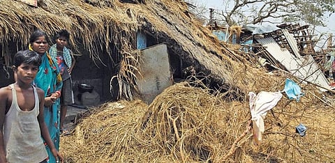
Take for instance cyclone Fani. Acco rding to K J Ramesh, director general of meteorology at India Meterological Department (IMD), his department, for the first time, deployed five doppler radars at specific points along the coast to accurately measure all parameters that brew up a cyclone. This includes the sea surface temperature, atmospheric pressure and the intensity and direction of local winds. They also analysed data related to the satellite imagery and warm sea pockets to simulate the cyclone. Yet, Fani kept IMD on its toes till the landfall. In fact, it just refused to move and kept meandering over the sea for 11 long days, making it the longest observed lifecycle of a cyclone over the Bay of Bengal. This slow movement was largely because of localised winds that steer the cyclones towards warmer ocean waters where it can gather more moisture and energy. But these localised winds are not easy to record.
IMD uses a scatterometer (instrument that measures dispersion of winds) placed on the weather monitoring satellites, such as the Indian Space Research Organisation’s (ISRO’s) SCATSAT-1 satellite launched in 2016, to measure winds near the ocean surface. But they do not provide images of required resolution.
“Currently, wind information is either derived from (satellite-based) temperature observations of clouds and is hence low resolution, or is measured directly through balloon measurements, measurements at the surface (weather stations, buoys and scatterometers over the oceans) and by aircraft,” says Josef Aschbacher, director of Earth Observation Programme at the European Space Agency (ESA).
“These cover only a few single points on the whole globe or a limited number of altitudes. The World Meteorological Organization has, therefore, identified the lack of direct global wind profile measurements as one of the major deficits in the current Global Observing System,” he adds. In August 2018, ESA launched the Aeolus satellite which is dedicated to measuring wind speeds using a Lidar radar, named Aladin. The data will be ready for commercial use by the end of the year.
But a number of scientists say clear disruptions in wind patterns are evident across the globe. These disruptions are making natural phenomena like cyclones, cold waves and monsoon currents more erratic and unpredictable.
At the Thompson’s Tropical Climate and Coral Reefs Laboratory in Boston University, USA, assistant professor Diane Thompson and post doctoral researcher Hussein Sayyani have observed that tropical Pacific trade winds, which bring monsoon winds to the tropical regions, are slowing down at several places like the Kiritimati island, Butaritari Atoll and Tarawa Atoll, located off the northeast of Australia. Their research is based on the analysis of wind speeds between 1894 and 1982, which they measured using trace metals like manganese in coral skeletons.
Concentration of trace metals usually spike in coral skeletons when stronger winds blow from the west carrying trace metals washed away from lagoon sediments. Pacific trade winds remain weaker during such periods. At Tarawa Atoll, for instance, they have found that the trade winds had weakened between 1910 and 1940, which was the first phase of global warming. Between 1940 and 1970, temperatures were more stable, and the trade winds were stronger. One source of powerful western winds could come from the El Niño phenomenon but Sayani and Thompson are still working to determine whether the change is triggered because of El Niño or climate change.
The slowing down of winds is, however, not a localised occurrence. Winds all across the world seem to be slowing down close to the land surface. The phenomenon is now referred to as stilling. The EU is funding a project, appropriately named STILLING, to understand the disruptive process. Researchers working with the project have found that the global terrestrial wind speeds have decreased by 0.5 km/hr every decade since the 1960s. Cesar Azorin-Molina, climatologist at the University of Gothenburg in Sweden and lead researcher of the project, says even though the value seems low it might have serious impacts.
“There are serious implications of wind changes in areas like agriculture and hydrology, basically because of the influence of wind on evaporation,” says Molina. Rapid urbanisation also makes land rough and reduces wind speeds. He and his team are now piecing together evidence and data on winds from old records, such as Portuguese weather books from the Azores island, which have compiled data since 1907, and the Blue Hill Observatory in Milton, USA, which has records beginning in 1885. This along with data from modern-day weather satellites will help them create a holistic understanding of planet-wide land-wind patterns.
But several other researchers are convinced that wind stilling is triggered by changing climate. The strength of winds depends on the temperature difference between cold and warm air. Warming of colder regions squashes this difference, making it uniform, which then leads to overall slowing down of winds. Consider the Arctic. According to the US National Oceanic and Atmospheric Administration, temperatures over the Arctic have risen by 2.30C since the 1970s. This is double the rate at which the rest of the world has warmed up.
This heating has destabilised the polar jet stream, a large band of winds that swirls around the Arctic and maintains the weather balance between the North Pole and the regions below. A study by researchers at the Potsdam Institute for Climate Impact Research in Germany, published in the journal Science Advances in November 2018, says in a warming world the Arctic jet stream will stall and become larger in certain places.
More cold winds will blow to lower latitudes, interfering with the westerly winds and altering the weather balance. “The westerly winds will stop pushing forward weather systems and a few sunny days will grow into heatwaves and extended rains will lead to floods,” says a press release by the institute. “We expect roughly a 50 per cent increase in the incidence of atmospheric conditions that favour a slow, broadly meandering jet stream and stalled weather extremes,” says Michael Mann, lead author of the study. This already happened during the record-breaking extreme cold weather conditions in North America and Europe in 2014 and again in 2018.
In India, where 60 per cent of the agriculture is rain-fed, this new phen-omenon will hinder the monsoon winds. In fact, the monsoon winds have become weaker in the last few decades leading to a decrease in overall rainfall on the Indian subcontinent, says a research paper published by scientists from the Harvard University, Peking University and Chinese Meteorological Administration in the journal Science Advances in December 2018. The study says significant warming in the Indian Ocean has decreased the temperature difference between the land and sea, which is the main trigger for the flow of monsoon winds. But more research is required to establish how these wind patterns are changing and altering the chemistry of cyclones. Till then cyclones like Fani will keep us on our toes.
With inputs from Vibha Varshney, Snigdha Das and Rajit Sengupta
(This article was first published in Down To Earth's print edition dated May 16-31, 2019)