
Subscribe

Archaeologists have used declassified spy satellite images to pinpoint the exact location of a decisive battle that took place in the 7th century between the Mesopotamian floodplain and the Arabian desert.
A team of archaeologists from Durham University in the United Kingdom and University of Al-Qadisiyah in Iraq compared declassified 1970s American spy satellite imagery to modern day images and historical texts to identify the site.
“Their analysis places the battle site 30km south of Kufa in the Najaf Governorate,” a statement by Durham University said.
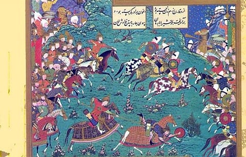
The Battle of Al-Qadisiyyah in 637/8 AD is a key event in the history of Islam. The forces of the Rashidun (‘Rightly Guided’) Caliph, Umar al-Khattab, led by Sa’ad ibn Abi Waqqas clashed with those of the Sassanian Emperor Yazdegerd III led by Rostam Farrokhzad.
The Rashidun Caliphate was one of the three powerful entities of its time in the Middle East, with its major rivals being the Christian Byzantine Empire (earlier Eastern Roman Empire) and the Zoroastrian Sassanian Empire, also known as the ‘Second Persian Empire’ as it emerged from Pars or Fars, also the birthplace of the earlier Achaemenid Empire.
The Arab Muslims were victorious in battle, which meant that Sassanid rule ended in Mesopotamia or modern-day Iraq. By 651 AD, the Arabs would conquer the whole of Greater Persia and subdue it, setting in motion the process of its Islamisation.
The team of archaeologists were carrying out a remote sensing survey of the Iraqi section of the Darb Zubaydah, a key Hajj pilgrimage route stretching from Kufa in Iraq to Mecca in Saudi Arabia and a tentative World Heritage Site.
The survey was carried out as part of the ‘Endangered Archaeology in the Middle East and North Africa’ project (EAMENA) to map the pilgrimage road.
“However, the team realised they were also able to use sites and structures detailed in the historical texts and visible on the satellite imagery, to accurately identify the location of the Battle of al-Qadisiyyah,” the statement by Durham University noted.
It added that “during their survey work the team identified a six-mile-long double wall feature. It linked a military complex on the desert fringe and a large settlement on the edge of the southern Mesopotamian floodplain”.
This finding corresponded remarkably well to details within the rich body of historical sources relevant to the battle of al-Qadisiyyah and the stopping points along the Darb Zubaydah.
The team identified the locations of two stopping points along the Darb Zubaydah – al-Qadisiyyah and al-‘Udhayb.
Scientists from the University of Al-Qadisiyah in Iraq, working with their British counterparts, were able to provide additional on-the-ground survey evidence to support the original findings.
Locating al-Qadisiyyah: mapping Iraq's most famous early Islamic conquest site has been published in the journal Antiquity.
