
Subscribe

The Grand Ethiopian Renaissance Dam (GERD)’s saddle dam, the largest and most critical auxiliary dam globally, is an active geohazard hotspot showing critical signs of instability. If breached could threaten downstream regions, threatening millions in Sudan and Egypt warned a study published in International Journal of Disaster Risk Reduction, March 2026.
The team at the Earth System and Data Solutions (ESSDS) lab in Chapman University (California), along with Yale University, conducted a comprehensive multi-sensor geohazard analysis of the Grand Ethiopian Renaissance Dam (GERD) saddle dam and identified several warning indicators.
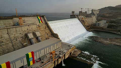
GERD, on the Blue Nile in Ethiopia, is complemented by a saddle dam approximately 5 kilometres long and 50 metres high.
The GERD saddle dam is unique because it holds up to 89 per cent of the GERD reservoir’s live storage, which is more than the average yearly flow of the Blue Nile at the GERD site. This makes it one of the largest saddle dams in the world with implications for downstream water security and flood risk in Sudan and Egypt.
The Blue Nile originates in Lake Tana in Ethiopia, before flowing through the country and Sudan to meet the White Nile in the latter’s capital of Khartoum. The combined stream flows north into Egypt, before emptying into the Mediterranean Sea near Alexandria.
Groundwater infiltration during reservoir filling was estimated at approximately 41 billion cubic meters. Satellite imagery showed new water zones near the saddle dam, suggesting seepage or leakage pathways that require urgent integrity and safety checks. Persistent Scatterer Interferometry (PSI) and imagery detected up to 40 millimeters of dam deformation and leakage, indicating the dam’s instability.
Poisson regression analysis indicated a statistically significant increase in seismicity linked to reservoir impoundment and concurrent volcanic activity, underscoring the potential for reservoir-induced seismic hazards.
The modeled dam breach scenario revealed catastrophic flood risks to downstream regions, threatening millions in Sudan and Egypt. According to the simulations, floodwater would reach Roseires dam (Sudan) within 5 hours and Khartoum within three days, causing extreme flooding with water depths reaching up to 34.7 meters in the main channel and waves of 0.8 m inundating surrounding buildings.
The entire city of Khartoum, the capital of Sudan would be affected, “experiencing flow velocities between 0 and 6.5 m/s, resulting in widespread devastation. Additionally, backpropagation would occur at the confluence of the White Nile and the main Nile river, further complicating the hydrodynamics of the region.”
The flood wave would impact major downstream dams along the Nile River, further exacerbating the disaster.
The findings provide compelling evidence that seepage and leakage processes are active, posing significant structural and hydrological risks that require continuous monitoring and international cooperation for effective risk management.
“These findings do not predict imminent failure, but they do identify measurable warning signals that require urgent international attention and transparent safety evaluation,” said Hesham El-Askary, the lead author from Chapman University, US. “The potential human and economic consequences of inaction are significant.”
The findings provide the first quantitative validation of the specific geotechnical risks forecasted during the pre-construction phase. In 2013, the International Panel of Experts (IPOE) on Grand Ethiopian Renaissance Dam Project (GERDP) warned of ‘hazardous seepage’ due to the high permeability of the saddle dam’s fractured foundation and the potential for differential settlement if foundation treatments were insufficient.
The results—especially the detection of massive groundwater infiltration (41 BCM) and the sudden emergence of downstream water bodies aligned with fault zones—serve as a direct realization of these early warnings. The PSI-derived accumulated differential subsidence (up to 40 mm) confirmed the IPoE’s concerns regarding the compressibility of the underlying strata.
The study underscored the critical need to revisit the safety recommendations originally proposed by the international panel to protect millions of people and key infrastructure along the Nile.
