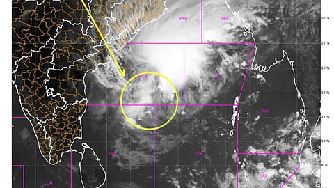


Cyclone Akvan in the Bay of Bengal is showing signs of unpredictable behaviour, with its movement slowing and the India Meteorological Department (IMD) downgrading its forecast peak intensity from a very severe cyclonic storm to a severe cyclonic storm. Different weather models have also produced varying predictions for the storm's track and further intensification. The projected landfall location has shifted further north in the IMD's latest updates.
At 11.30am on November 18, 2026 severe cyclonic storm Akvan was located about 540 kilometres south-east of Narsapur and 570 km east of Chennai, according to the latest IMD update posted on X (formerly Twitter).
The weather agency predicted that the cyclone could make landfall between Narsapur in Andhra Pradesh and Puri in Odisha around noon on November 20, with sustained wind speeds of 90–100 km per hour and gusts of up to 110 km/h.
In an earlier update, issued just a few hours before, the IMD had forecast landfall between Nellore and Visakhapatnam in Andhra Pradesh, with sustained wind speeds of 100–110 km/h and gusts of up to 120 km/h.
During the night of November 17-18, the cyclone moved at speeds as low as 3km/h. Its forward speed increased to 7-8 km/h on the morning of November 18, according to the IMD.
As the system is within the COL region between two anticyclones, it is moving slowly during past 12 hours further as the system moving slowly in the moderate vertical wind shear environment, its intensification has been slow
IMD
"However from November 18, the ridge to the east of the system is very likely to dominate leading to northwestwards to north-northwestward movement with higher translational speed," the agency added.
The IMD highlighted significant differences between weather models over the cyclone's movement, intensification, landfall location and timing.
"Regarding further intensification, there exist large uncertainty among different models," the IMD said.
Forecasts from the European Centre for Medium-Range Weather Forecasts (ECMWF) and artificial intelligence-based weather models suggested that the storm could weaken below tropical cyclone intensity before landfall, according to the IMD.
This possibility was also reflected in forecasts displayed on the weather visualisation platform Windy.com. ECMWF data visualised on the platform also indicated significant rainfall across coastal and interior parts of Odisha due to Cyclone Akvan.