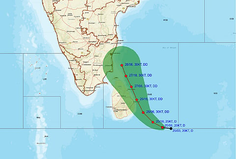

The depression over the Southwest Bay of Bengal and adjoining East Equatorial Indian Ocean is moving towards the Sri Lanka and Tamil Nadu coasts and could likely make landfall between Chennai and Puducherry, according to the India Meteorological Department (IMD).
“…the depression over central parts of South Bay of Bengal and adjoining East Equatorial Indian Ocean is likely to move northwestwards and intensify into a deep depression during next 24 hours. Thereafter, it is likely to continue to move northwestwards towards Tamil Nadu-Sri Lanka coasts during subsequent 2 days,” the latest bulleting of the IMD said.
The agency noted that the depression moved west-northwestwards with a speed of 30 kilometres per hour during the past 3 hours.
It lay centred at 1130 am on November 25 morning over Southwest and adjoining East Equatorial Indian Ocean near latitude 5.1°N and longitude 84.5°E, about 530 km south east of Trincomalee, 810 km southeast of Nagappattinam, 920 km southeast of Puducherry and 1000 km south-southeast of Chennai.
IMD noted that there was still variation (though reduced) among various models with respect to track, intensification and landfall of the system.
“Peak intensification is varying from depression to marginal cyclonic storm stage. However, most of the models are indicating the system to make landfall over the Tamil Nadu coast and weaken slightly prior to landfall. The landfall point is varying between Puducherry and Chennai (12-13N), landfall time is varying between 29/1200 UTC & 30/0600 UTC and intensity from 15-30 KT,” the IMD statement noted.
If the depression becomes a cyclone, it will be called ‘Fengal’. It would be coming in the wake of Dana. It was the third cyclonic storm and second severe cyclonic storm of the 2024 North Indian Ocean cyclone season.