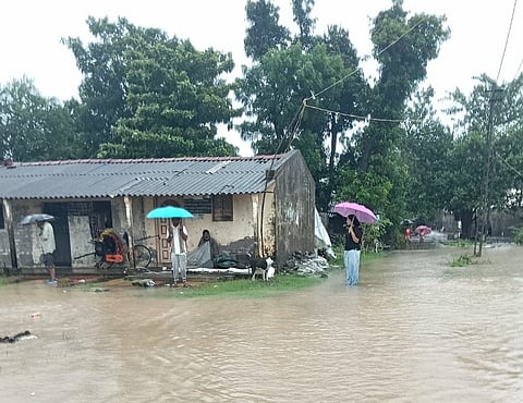


Gujarat remains under red alert as extremely heavy rainfall raises flood concerns, with 13 districts placed on high alert.
The low-pressure system over southeast Rajasthan is weakening, but heavy rainfall will continue across several states for another 24 hours.
Kerala, Coastal Karnataka, Konkan, Goa and parts of Maharashtra are expected to receive heavy to very heavy rainfall today.
Delhi, Himachal Pradesh, Uttarakhand, Bihar and several other states may witness heavy rain, thunderstorms and strong winds today.
The weather department has advised people to avoid unnecessary travel and follow official warnings as the active monsoon continues.
India’s southwest monsoon continues to remain highly active, bringing relentless rainfall across large parts of the country and prompting weather authorities to issue multiple alerts. Although the well-marked low-pressure area over southeast Rajasthan is expected to weaken into a regular low-pressure system within the next 24 hours, its influence is likely to sustain intense rainfall across several states.
According to the latest weather bulletin, the system is moving west-northwest while interacting with other active weather features, including the monsoon trough stretching from Rajasthan through Madhya Pradesh, Chhattisgarh and Odisha. An east-west shear zone over central India and an active western disturbance near Himachal Pradesh are further enhancing rainfall activity, increasing the risk of flooding and disruption.
Gujarat remains the worst-affected state, with the India Meteorological Department issuing a Red Alert for extremely heavy rainfall. Several regions are expected to receive rainfall exceeding 204.5 mm, raising fears of flash floods, waterlogging and overflowing rivers. In response to the deteriorating situation, the state government has declared a high alert in 13 districts and placed disaster response teams on standby. Authorities have warned that the threat of flooding is likely to remain significant until at least August 2, urging residents in vulnerable areas to remain cautious and avoid unnecessary travel. Continuous rainfall has already disrupted normal life in several districts, with low-lying areas particularly at risk.
Kerala and Mahe are also under Orange to Red Alerts as forecasts indicate heavy to extremely heavy rainfall in many places. Coastal Karnataka, Konkan and Goa, Madhya Maharashtra, Lakshadweep and South Interior Karnataka are expected to receive between 115.6 mm and 204.4 mm of rainfall. The active monsoon over the Arabian Sea continues to feed moisture into the western coast, creating favourable conditions for prolonged spells of rain. Weather officials have cautioned that landslides in hilly regions and waterlogging in urban centres remain significant concerns throughout the weekend.
Beyond the western coast, widespread rainfall is forecast across a large part of the country. Delhi, Haryana, Punjab, Himachal Pradesh, Uttarakhand, Bihar, western Rajasthan, Tamil Nadu, Jammu and Kashmir, the northeastern states and the Andaman and Nicobar Islands are all expected to experience heavy rain accompanied by thunderstorms. Yellow Alerts have been issued in these regions, with rainfall ranging between 64.5 mm and 115.5 mm in isolated places. While not as severe as the conditions expected in Gujarat and Kerala, the showers may still disrupt transportation, affect agriculture and cause temporary flooding in low-lying localities.
The weather department has also warned of gusty winds and lightning across several regions. Wind speeds of 50 to 60 kmph are likely over North Interior Karnataka, while Kerala, Andhra Pradesh, Tamil Nadu, Jharkhand and parts of Madhya Pradesh may witness winds reaching 40 to 50 kmph. Bihar, Odisha, Telangana, Uttarakhand and eastern Uttar Pradesh are also expected to experience thunderstorms with lightning. Despite widespread rainfall, some regions continue to record above-normal temperatures. Parts of western Rajasthan, Gujarat, Tamil Nadu, Uttar Pradesh and Uttarakhand have reported daytime temperatures three to five degrees Celsius above average, resulting in uncomfortable humidity where rainfall has remained intermittent.
Recent observations underline the intensity of the ongoing monsoon, with Thiruvananthapuram recording 80 mm of rainfall, Minicoy 70 mm, Ahmedabad 70 mm and Vadodara Airport 60 mm during the past 24 hours. Jaisalmer remained the hottest place in the plains with a maximum temperature of 41.8 degrees Celsius, while Boudh in Odisha recorded the lowest minimum temperature at 18 degrees Celsius. The India Meteorological Department has advised citizens to monitor official weather updates closely, avoid travel to flood-prone areas and follow instructions issued by local authorities. With multiple weather systems remaining active, the coming 24 hours are expected to be particularly crucial for Gujarat, southern Rajasthan, Kerala and several parts of India’s western coastline.
