
Subscribe

A western disturbance has brought thunderstorms, hail and strong winds to north India, offering temporary relief from intense heat.
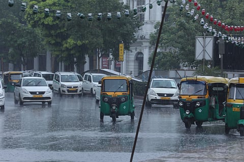
The IMD has issued alerts after gusty winds of up to 120km/h disrupted normal life in parts of Delhi-NCR.
Heavy to very heavy rainfall is expected across the Northeast, including Assam, Meghalaya and Arunachal Pradesh, raising the risk of floods and landslides.
The southwest monsoon has strengthened over southern India, with Kerala, Karnataka and Tamil Nadu seeing widespread heavy rainfall.
The monsoon has also advanced into parts of Maharashtra, Bihar and Jharkhand, raising hopes for the kharif sowing season.
Heatwave conditions persist in isolated pockets, including parts of Rajasthan, Maharashtra and southern coastal areas.
Weather conditions across India have turned sharply dynamic as a strong western disturbance interacts with an active monsoon system, bringing widespread thunderstorms, rain and hailstorms to northern parts of the country, while heavy to very heavy rainfall continues over the Northeast and southern states.
The India Meteorological Department (IMD) has indicated that the evolving weather pattern is likely to persist over the coming days, with significant regional variations.
A western disturbance has brought thunderstorms, hail and strong winds across north India, offering relief from intense summer heat. The monsoon has also advanced steadily, causing heavy to very heavy rainfall across Northeast India and increasing the risk of floods and landslides.
Southern states are experiencing intense monsoon showers, with Kerala, Karnataka and Tamil Nadu witnessing widespread heavy rainfall activity.
Temperatures have dropped in north India, while heatwave conditions persist in parts of Rajasthan, Maharashtra and southern coastal areas. The IMD has issued alerts as gusty winds of up to 120 kilometre per hour (kmph) disrupted normal life across the Delhi-National Capital Region.
North India, including Delhi, Haryana, Punjab, Rajasthan, Uttar Pradesh, Uttarakhand, Jammu and Kashmir and Himachal Pradesh, witnessed a dramatic change in weather as strong dust storms, gusty winds, rainfall and isolated hailstorms swept through several regions.
The sudden shift has brought temporary relief from the intense heat and humidity that had gripped the region in recent days. According to meteorological assessments, wind speeds in some areas of the National Capital Region reached 70-120 kmph during storm activity, triggering orange alerts and prompting precautionary advisories.
The system has also contributed to a noticeable dip in temperatures, with maximum and minimum readings expected to fall significantly over the next 48 hours.
While the cooler weather has been welcomed by residents, the intensity of the storm system has raised safety concerns. The IMD has warned of thunderstorms accompanied by hail in several northern states. The most vulnerable regions include hilly terrain and open agricultural fields, where strong winds may damage crops and infrastructure.
Authorities have advised people to avoid open areas during thunderstorm activity and take precautions, especially during lightning strikes. The risk of falling trees and temporary disruption to transport networks has also increased because of the high wind speeds.
In contrast to north India’s fluctuating weather, the Northeast continues to experience sustained heavy rainfall. States such as Assam, Meghalaya and Arunachal Pradesh have been placed under orange alerts because of the likelihood of very heavy rainfall ranging between 115mm and more than 200 millimetres in isolated pockets.
Other northeastern states, including Nagaland, Manipur, Mizoram and Tripura, are also expected to witness thunderstorms accompanied by intense showers under a yellow alert. Continuous rainfall in these regions raises the possibility of localised flooding and landslides, particularly in hilly and low-lying areas.
The southwest monsoon has further strengthened over southern India, bringing widespread rainfall across several coastal and interior regions. Kerala, Karnataka and Tamil Nadu are witnessing heavy to very heavy rainfall under active monsoon conditions. Coastal belts, in particular, remain under close watch because of the possibility of waterlogging and flash floods.
Rainfall activity has also expanded into Andhra Pradesh, Telangana and parts of Odisha, signalling a steady advance of the monsoon system across central and eastern India. The advancing monsoon has also moved into parts of Maharashtra, Bihar and Jharkhand, raising hopes among farmers for a strong start to the kharif sowing season.
The IMD has indicated that the monsoon is likely to progress further into additional parts of central and northern India over the next few days, depending on atmospheric conditions. Weather officials have also highlighted significant fluctuations in temperature patterns.
Northwestern India is expected to see a drop of 5-7 degrees Celsius in maximum temperatures because of storm activity, followed by a gradual rise after mid-June. Central India is likely to see relatively stable temperatures in the immediate term before minor fluctuations occur.
In contrast, some regions in western India, including parts of Maharashtra, may experience a temporary rise in temperature before stabilising later in the month. Extreme heat conditions persist in isolated pockets, with Jaisalmer in Rajasthan recently recording one of the highest temperatures in the country at 46°C .
Overall, India’s weather pattern remains highly dynamic, shaped by the simultaneous influence of a western disturbance and an active monsoon system.
While northern regions are experiencing temporary relief from heat because of storms and rainfall, eastern and southern parts continue to face intense monsoon activity.
The IMD has advised people to stay updated with local weather alerts, as conditions are expected to remain changeable, with the risk of thunderstorms, heavy rain and localised extreme weather events over the coming days.
