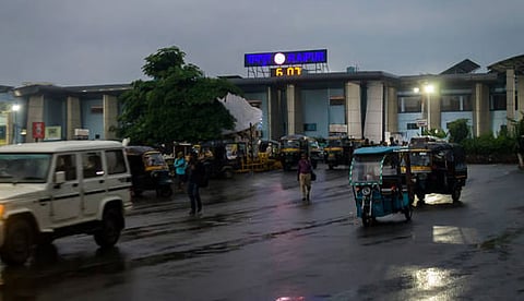


Heavy to extremely heavy rainfall likely across Odisha and Chhattisgarh, with thunderstorms, lightning, gusty winds and widespread disruptions expected.
Low-pressure system over Bay of Bengal likely to move northwestwards, intensifying rainfall across Odisha, West Bengal and neighbouring states.
Uttarakhand faces serious flood and landslide risks as persistent rainfall disrupts roads, raises river levels and threatens vulnerable mountainous areas.
Bihar, Jharkhand and northeastern states may receive heavy to very heavy rainfall, prompting orange alerts and widespread weather precautions.
Delhi likely to remain hot and humid, with partly cloudy skies, limited rainfall chances and temperatures touching around 37°C today.
The monsoon has once again strengthened across several parts of India, with heavy to extremely heavy rainfall forecast in Odisha, Chhattisgarh and a number of eastern, northeastern and Himalayan states. According to the weather update issued on August 31, a low-pressure area over the northwest Bay of Bengal and adjoining areas of West Bengal and north Odisha is expected to move west-northwestwards during the next 24 hours. The system is likely to approach north Odisha and the Gangetic West Bengal region, increasing rainfall activity across the region.
Thunderstorms, lightning and strong winds are also likely in several areas. The intensifying weather system has prompted authorities and residents to remain alert, particularly in districts vulnerable to flooding and waterlogging.
Odisha and Chhattisgarh are among the states facing the most significant threat from the developing weather system. The India Meteorological Department has warned of heavy to very heavy rainfall in several areas, with isolated pockets potentially receiving extremely heavy rainfall exceeding 204.5 millimetres.
Parts of Odisha may also experience lightning and gusty winds during thunderstorms. Orange and red alerts have been issued for different areas, underlining the possibility of disruption to normal life, transport and agricultural activities.
Heavy to very heavy rainfall is also expected in parts of Arunachal Pradesh, Bihar, eastern Uttar Pradesh, Jharkhand, Nagaland, Manipur, Mizoram and Tripura. These regions have been placed under an orange alert, with rainfall totals potentially ranging between 115.6 to 204.4 millimetres.
Assam and Meghalaya, eastern Madhya Pradesh, West Bengal and Sikkim, and western Uttar Pradesh are also likely to receive heavy rain, with yellow alerts issued for several areas.
Uttarakhand continues to face the consequences of persistent rainfall, with Chamoli and Pithoragarh among the worst-affected districts. More than 70 roads have reportedly been disrupted, creating difficulties for residents and travellers.
On August 31, an orange alert for heavy to very heavy rainfall is in force in Dehradun, Bageshwar, Chamoli and Nainital. Several other districts, including Tehri, Pauri, Rudraprayag, Pithoragarh, Uttarkashi, Champawat and Udham Singh Nagar, are also expected to experience heavy rain, thunderstorms and lightning.
Rising water levels in rivers and streams have increased the possibility of flash floods and landslides, particularly in vulnerable mountainous areas. Residents have been advised to avoid unstable slopes, riverbanks and streams and to follow directions issued by local authorities.
Himachal Pradesh is witnessing heightened weather activity, with yellow alerts for Kangra, Mandi and Sirmaur. Chamba, Bilaspur, Una and Hamirpur may also receive rainfall, while Shimla and surrounding areas could see intermittent heavy showers accompanied by thunderstorms.
Jammu and Kashmir and Ladakh may also experience light to heavy rainfall as a western disturbance remains active over northern Pakistan and adjoining Jammu areas.
While much of eastern and northern India prepares for rain, Delhi is expected to remain comparatively dry. The capital may see partly cloudy skies, but the probability of significant rainfall is low. Temperatures are likely to range from around 27 degrees Celsius at night to nearly 37 degrees Celsius during the day, with southwesterly winds reaching 20 to 25 kilometres per hour.
Despite widespread rainfall, several parts of India continued to record temperatures above normal. Arunachal Pradesh, Assam and Meghalaya saw maximum temperatures more than 5.1°C above normal, while Assam and Meghalaya also recorded significantly higher-than-normal minimum temperatures.
Night temperatures remained above normal in parts of Sub-Himalayan West Bengal and Sikkim, eastern and western Uttar Pradesh, Himachal Pradesh, western Madhya Pradesh and Saurashtra-Kutch.
On August 30, the highest maximum temperature among the country’s plains was 40°C, recorded at Sri Ganganagar in Rajasthan and Madurai in Tamil Nadu. The lowest minimum temperature was 18.5°C, recorded at Haflong in Assam.
The widespread rainfall has important implications for agriculture and daily life. Farmers have been advised to maintain proper drainage in fields, protect harvested crops and avoid spraying fertilisers or pesticides during rainy conditions. Livestock should also be moved to safer, elevated locations.
For the public, unnecessary travel during intense rainfall should be avoided. People should stay away from flooded roads, rivers and streams and never shelter under trees during thunderstorms. With the possibility of lightning, flash floods and landslides in vulnerable regions, staying indoors and following official weather and local administration advisories remain the safest course.
