
The extreme rainfall and flooding in different parts of Delhi and the National Capital Region (NCR) on the intervening night of June 27-28 is a result of a rapid and strong onset of the southwest monsoon in the presence of an active western disturbance (WD), meteorologists and weather scientists have told Down To Earth (DTE).
The southwest monsoon-WD interaction had been rare in the past. But it is becoming more frequent now because of changes in the character of WDs.
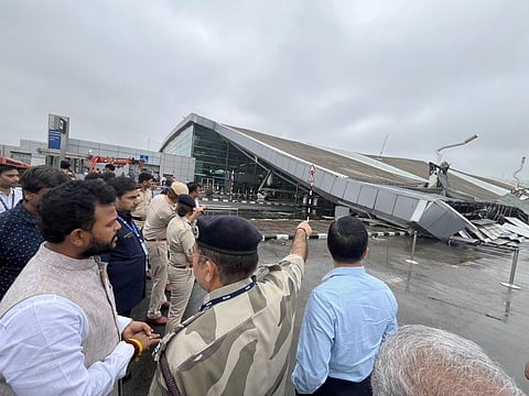
The rains over Delhi on June 27-28 were so heavy and intense that the roof of Terminal 1 of the Indira Gandhi International Airport collapsed, killing at least one person and injuring eight others, according to media reports. Many parts of the city have been flooded and are under water.
The Safdarjung observatory of the India Meteorological Department (IMD) recorded 228 millimetres (mm) rainfall up till 8:30 am on June 28, according to independent weather forecaster Navdeep Dahiya on social media platform X. This is the second highest June rainfall recorded at the observatory. The highest recorded rainfall for June was 235.5 mm on June 28, 1936.
The primary reason behind the extreme rainfall is the onset of the southwest monsoon over the region on June 28. The onset was quite rapid and intense after the long hiatus from early to mid-June. In fact, the Bay of Bengal branch of the monsoon was stalled for 19 days between May 31 and June 19.
“The eastern edge of the trough curled up rapidly as the western edge jumped forward to the north as well. It was stuck around Mumbai for almost two weeks,” Raghu Murtugudde, a professor at the Indian Institute of Technology, Bombay and emeritus professor at the University of Maryland, told DTE.
“The main driver I see is that the low-level jet finally picked and had a nice southern branch going into the Bay and turning back to the core monsoon zone,” Murugudde added.
But there were other factors as well, one of which was the presence of a WD and an associated cyclonic circulation over the region.
WDs are extra-tropical storms that travel along the subtropical jet stream, bringing the majority of seasonal and extreme precipitation to the Hindu Kush, Karakoram and western Himalaya in the winter months. These moisture-laden storms are vital for the region’s water security and agriculture. However, WDs now appear more frequently during summers than before.
IMD had pointed out in its statement on June 27 that a WD as a trough or an extended low-pressure region was along the 64 E longitude and 28 N and latitude. A cyclonic circulation associated with the WD was over northwest Rajasthan, according to the weather agency.
An analysis by Kieran M R Hunt, meteorologist at the National Centre for Atmospheric Sciences, University of Reading, UK, published in the journal Weather and Climate Dynamics of the European Geoscience Union in March 2024 shows that WDs are becoming far more common in May, June, and July, months where they were previously rare.
For example, WDs have been twice as common in June in the last 20 years than during the previous 50. Hunt attributes this to a strengthening of the subtropical jet stream and its delayed northward retreat, which historically had occurred before the onset of the summer monsoon. This is leading to their interaction with the monsoon trough leading to catastrophic floods that were witnessed in Uttarakhand in 2013 and Himachal Pradesh in July 2023.
Another factor responsible for the torrential rains was the excess moisture being pumped into northwest India from the warm Arabian Sea.
“This is classic system associated with the active phase and this allowed the jet to also occupy all of the Arabian Sea and pump huge amounts of moisture into northwest and central India. Now the trough is in a full Paschimottasana,” explained Murtugudde.
The rainfall in northwest India may continue at least till July 1, as per the latest forecast by IMD. This could bring copious rainfall for the Himalayan states where flash floods and landslides could cause devastation.
“I expect more heavy rain and we have to watch out for the Himalayan foothills and landslides because the warm northern Arabian Sea is pumping a lot of moisture into Gujarat and northward,” said Murtugudde.