
Subscribe

Climate models show early signs of a possible El Niño developing in 2026.
Forecasters say warming in the equatorial Pacific is weakening La Niña conditions.
A renewed El Niño could push global temperatures closer to or above 1.5°C.
Scientists warn of increased risks of heatwaves, droughts and extreme weather.
Similar signals were observed ahead of the 2023–24 El Niño event.
The equatorial Pacific Ocean is showing early signs of a possible return of El Niño conditions, which could begin in the second half of 2026 and peak during the northern hemisphere winter, according to climate analysts. Scientists warn that a renewed El Niño could reinforce the current upward trend in global temperatures.
“Latest forecast data shows an El Niño to return in 2026, strengthening in the second half of the year and lasting through the 2026-2027 season,” according to Severe Weather Europe, a European weather and climate analysis platform.
Such a development could mean another year at or close to the 1.5°C warming threshold above pre-industrial levels, alongside a heightened risk of more frequent and intense heatwaves, droughts, wildfires and other associated impacts of intense planetary and regional warming.
El Niño is the warm phase of the El Niño-Southern Oscillation (ENSO), a natural climate cycle during which global average temperatures tend to be higher than normal. The phenomenon alters rainfall patterns worldwide, bringing wetter conditions to some regions and drier weather to others. In India, several past monsoon droughts have been linked to El Niño conditions in the Equatorial Pacific Ocean.
“During an El Niño event, pressure over the tropical Pacific is lower, leading to increased rainfall and storm activity in this region,” Severe Weather Europe said. Rising air in the eastern Pacific increases rainfall and lowers atmospheric pressure there, while sinking air over the western Pacific leads to higher pressure and more stable weather.
These changes in atmospheric pressure and rainfall over the equatorial Pacific can propagate across the globe, influencing weather patterns far beyond the region. In India, this often results in suppressed rainfall during the monsoon season.
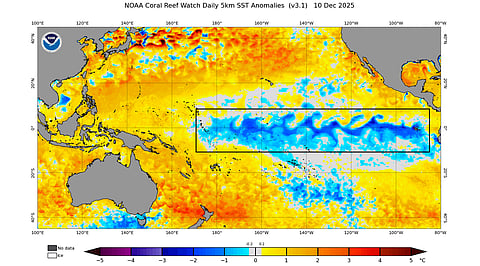
At present, weak La Niña conditions — the colder than normal phase of ENSO — persist in the equatorial Pacific. These peaked in November and are expected to weaken further during the northern hemisphere winter.
“But lately, the ENSO temperature anomaly has started to rise back, signalling that the end has begun for the La Niña,” Severe Weather Europe said. Warming in the equatorial Pacific is beginning in the west, a trend visible in sea surface temperature anomaly data.
More pronounced signals of a potential El Niño are emerging beneath the ocean surface. “The image below shows the subsurface ocean temperature anomalies. You can see a large warm pool in the west, at around 100-250 metres depth (300-800 feet),” Severe Weather Europe said. “This is one of the reasons for the La Niña weakening from the west, as these warm anomalies expand below the surface.”
Seasonal forecasts also point to a shift towards El Niño conditions. “The main clear indication of the El Niño on the horizon is seen in the latest seasonal forecast for the ENSO region,” the platform said. “The ECMWF forecast takes it into the proper El Niño range during Summer 2026, lasting well into Winter. Currently, this indicates a moderate strength event, but it typically ends up stronger than forecast.”
The current signals in sea surface temperatures, subsurface ocean heat and forecast models resemble conditions observed ahead of the last El Niño event in 2023-24. That episode coincided with record-breaking global monthly and annual temperatures and was partly responsible for 2024 becoming the warmest year on record — and the first to exceed the 1.5°C warming threshold.