
The intensity of cyclones, hurricanes and typhoons might increase in the next century due to global warming, a new joint British-American study has said.
Scientists from the National Oceanic and Atmospheric Administration (NOAA) and Princeton University in the United States and University of East Anglia in the United Kingdom analysed 90 peer reviewed articles to understand the impact of a changing climate on tropical cyclones — a combined name used for the three cyclonic storms.
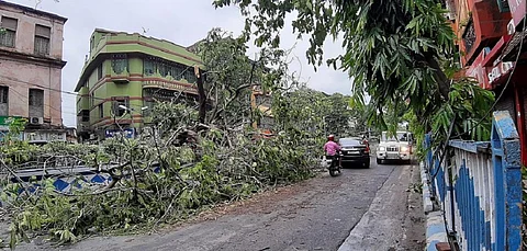
They concluded that there could be a five per cent increase in maximum cyclonic wind speeds if the world warmed by two degree Celsius by 2100. Wind speeds of a cyclone can peak at more than 300 kilometres per hour and cause damage to public infrastructure like electric poles, houses and vegetation.
Cyclones, hurricanes and typhoons are the same but named differently based on which ocean they form in. They are created by warm ocean waters.
Rising sea water levels will likely intensify the destructive impact of the cyclonic storms due to increased storm surges which inundate coastal areas during an ongoing storm, bringing in sea-water that decreases soil fertility and corrodes buildings.
To add to the misery, the amount of rainfall carried by the storms might also increase by an average of 14 per cent due to the warming-fuelled increase in moisture in the atmosphere which can cause more intense floods.
Hurricane Dorian — a Category 5 storm — in September 2019 had drowned the Bahamas islands as it moved at a slow pace. Slow moving storms generally carry more rainfall. Typically, a cyclone moving at around eight km per hr can cause up to 760 millimetres (mm) of rainfall. For a long period in its path, Dorian had moved at around 1.5 km per hr.
There are other impacts of warming on tropical cyclones such as rapid intensification which could make them unpredictable and difficult to monitor. Rapid intensification happens when there is an increase of maximum sustained winds of a cyclone by at least 55 kilometres per hour within 24 hours.
In 2020, Cyclone Amphan displayed rapid intensification when it developed from a cyclone (wind speeds of 70-80 km per hr) to a super cyclone (wind speeds in excess of 220 km per hr) in about 40 hours.
Stronger storms might occur in areas closer to the North and South Poles which means that seas in these regions are becoming warmer. Countries which had never felt the impacts of cyclones might start witnessing them.
“The influence of climate change on tropical cyclones has been notoriously difficult to separate from natural variability. But an increasingly consistent picture is emerging that suggests human activities are probably influencing some aspects of these extreme weather events, although the exact extent of the human influence is still difficult to determine confidently in today’s observations,” says a press release from the scientific team.
The influence of the warming on the storms can already be seen. For instance, the researchers sifted through data since 1979 and found that the proportion of severe cyclones of categories 3-5, based on the metric called the Saffir-Simpson hurricane wind scale, had increased by five per cent per decade.
The impact was especially visible in the North Atlantic Ocean. “The 2020 hurricane season in the North Atlantic had both a high number of named storms and a high number of intense hurricanes, with six storms in Category 3 to 5,” Gabriel Vecchi, professor of geosciences at Princeton University and a co-author of the study, said.
In the North Pacific Ocean, the intensity of tropical cyclones making landfall along the coasts of eastern and south eastern Asia from 1977-2014 had increased by 12-15 per cent.
In the Indian Ocean region, the chances of cyclonic disturbances on the sea surface, known as low pressure areas, transforming into cyclones have increased in the Arabian Sea, according to a research paper published by scientists from the India Meteorological Department (IMD) in 2015.
The research analysed data from 1951-2010. This has happened because of a decrease in vertical wind shear, which are localised winds around a cyclone in the vertical direction, in the Arabian Sea.
When they are strong, they usually destabilise a cyclone and make it less intense. In 2019, five out of the eight cyclones that impacted India formed in the Arabian Sea. The average number of annual cyclones in the Arabian Sea is one.
In the Bay of Bengal, the paper said the number of cyclones growing to become severe cyclones had increased. This had happened because of low level cyclonic vorticity which intensified cyclones.
The study was published in the ScienceBrief Review.