
Subscribe


This May, India has seen an unprecedentedly early and rapid monsoon. The India Meteorological Department (IMD) officially reported Kerala’s monsoon onset on May 24—a full week earlier than the usual June 1. Mizoram experienced rainfall on the same day, roughly 12 days earlier than normal. By May 26, the monsoon had reached Mumbai (its earliest arrival in 25 years) and was sweeping across Maharashtra, Karnataka, Telangana and even parts of Northeast India. Normally it takes 10-11 days for the monsoon to progress from Kerala to Mumbai, but this year that journey took barely two days.
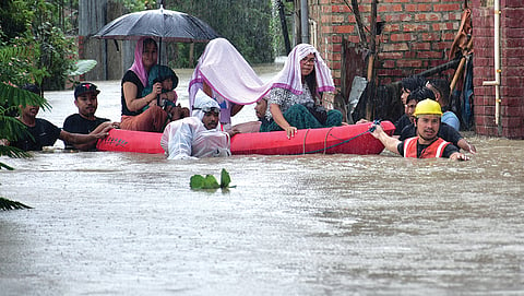
Even before the calendar monsoon began, India saw torrential, unseasonal rain in May. An unusually high incidence of Western Disturbances, which are Mediterranean-origin storm systems, penetrated deep into India throughout May. IMD data record five to seven Western Disturbances in May 2025, well above the norm of one or two. The systems unleashed thunderstorms and heavy rains, breaking the usual pattern of searing heat. In the first week of May, half of India’s 728 districts were already reporting large excess rainfall (more than 60 per cent of the normal rainfall for the week). By the last week of the month, the share of districts with large excess rainfall increased to 61 per cent.
Delhi has now recorded its wettest May since 1901. Even arid Marathwada and Rayalaseema were green with excess rain by month’s end. Drought-prone Latur district in Maharashtra exemplified the swing: it began the month with about 75 per cent below normal rainfall, but by late May was at a 2,000 per cent surplus. Southern and central India—Maharashtra, Gujarat and Tamil Nadu—reported widespread crop damage from unseasonal rain, and Uttar Pradesh’s mango growers saw blossoms being washed out.
The ferocity and abrupt timing of the rains caught forecasters off-guard in places. Take Latur, normally infamous for drought. On May 27, the city received 264.5 mm of rain—about seven times the normal May rainfall. Yet IMD’s regional forecasts had predicted nothing so extreme. The Mumbai office’s bulletin for May 27 mentioned only “thunderstorm, lightning and strong surface winds” for Latur and its surroundings. IMD’s national press release read “isolated heavy rainfall” in Marathwada that day.
Meanwhile, the Northeast had endured an unusually dry pre-monsoon spell: Mizoram had about 55 per cent below-normal rainfall from March to late May. Tripura and other states were 25-40 per cent below normal. IMD’s pre-season outlook did flag a possible dry trend in the Northeast, but forecasts could not precisely time the transition to monsoon rains. When the southwest monsoon surged in over Mizoram on May 25, parts of the Northeast saw sudden heavy rain after weeks of drought-like dryness. IMD press releases on May 26 and 27 did issue thunderstorm and heavy rainfall outlooks for Assam and Meghalaya, but the rapidity of the northward onset remained astonishing to forecasters.
Why did forecasts miss the deluge? Part of the reason could be that most warnings focus on the daily total figures or synoptic patterns, not on hour-scale extremes. According to M Rajeevan Nair, former secretary of Union Ministry of Earth Sciences, there is nowadays a trend of seeing heavy rainfall in very short periods, as experienced in Mumbai. “This tendency is associated with global warming,” says Nair. But forecast models and alerts have traditionally targeted 24-hour events, so the few torrential hours can slip through the cracks. “Therefore, we need to understand the dynamics of sub-daily rainfall extremes and improve their prediction,” he says, adding that forecasters have never looked at sub-daily rainfall in the past.
Nair recently co-authored a research study which found that the frequency of short-duration heavy rainfall events (HREs) over central India and long-duration HREs over the northern west coast has increased in the recent decades, compared to earlier decades.
“This is the first study to address these issues based on IMD’s hourly rainfall data. We need more similar studies and develop an early warning system for sub-daily rainfall variations. This is a tough task, but we should do it,” he says.
Scientists emphasise that no single cause can fully account for the anomalous behaviour of the 2025 monsoon. Rather, it was the result of a perfect storm of overlapping factors. One of the drivers could be the unusually high number of West-ern Disturbances that struck India during May. These extratropical storms carried significant moisture and brought unseasonal rainfall to central and northern India. Their interaction with local weather systems also triggered thunderstorms and dust storms, creating a turbulent prelude to the monsoon.
Another important contributor could be the enhanced atmospheric moisture content, driven by record-high land and sea surface temperatures. Warmer air holds more moisture—scientific estimates suggest that the atmosphere’s water-holding capacity increases by roughly 7 per cent for every 1°C rise in temperature. As Nair explains, this “bigger bucket” effect intensifies rainfall events, allowing short bursts of precipitation to release extraordinary volumes of water.
Meteorologists also highlight the influence of large-scale atmospheric waves and pressure systems that appeared to “pull” the monsoon forward. In particular, a sequence of equatorial Rossby waves moving westward could have played a role in enhancing rainfall and accelerating the onset of the monsoon, says K S Hosalikar, a climate scientist and former head of Climate Research and Services at IMD Pune.
Simultaneously, strong westerly to southwesterly winds and an upper-level low-pressure system over the Arabian Sea helped transport moisture deep inland. This was accompanied by an upper-air trough extending from a depression over the Bay of Bengal westwards, which linked up with the Arabian Sea branch of the monsoon.
Together, these interconnected systems appear to have hastened the northward movement of the monsoon, Hosalikar adds. Experts suggest that these dynamics created a kind of atmospheric tug-of-war, dragging rain-bearing clouds up the subcontinent far more rapidly than usual.
Favourable global climate conditions further reinforced these developments. Nair points to an early northward shift in the Intertropical Convergence Zone (ITCZ), a band of tropical clouds that effectively signals the arrival of the monsoon. According to him, favourable atmospheric conditions over the Indo-Pacific basin may have triggered this early migration, setting the stage for the swift monsoon onset over Kerala and its rapid advance into the interior.
Additionally, the pre-monsoon drought-like conditions in the Northeast may have inadvertently contributed to the speed and strength of the incoming rains. Climatologists argue that extremely dry soils can enhance the initial convective response when moisture-laden winds arrive. By late May, when the monsoon surge reached Mizoram and other northeastern states, it encountered arid surface conditions that may have allowed for a rapid and vigorous atmospheric response. Although the exact mechanism remains an area of ongoing research, this gradient between dry land and incoming moisture likely helped accelerate the transition.
This article was originally published in the June 16-30, 2025 print edition of Down To Earth