

The ongoing super El Niño could become the strongest on record since 1950, with the World Meteorological Organization (WMO) forecasting a peak around December 2026.
Sea surface temperatures in the Niño 3.4 region of the equatorial Pacific have reached record levels, with anomalies projected to rise to approximately 3.7°C above normal.
Around 2.6 billion people worldwide could experience unusually high temperatures through December, according to meteorologist Ben Noll.
Drought conditions could intensify across parts of India, Africa, Central and South America, Indonesia and the Pacific, while extreme rainfall could threaten around 1.3 billion people globally.
The WMO forecasts a near-100% likelihood of El Niño persisting through February 2027, with its influence on weather patterns potentially continuing into spring.
The ongoing El Niño event in the equatorial Pacific Ocean, which is already breaking records, is projected to become the strongest since observations began in 1950, potentially surpassing even the 1876-1878 El Niño, whose strength is known only from reconstructed data. The World Meteorological Organization (WMO) forecasts that the event will peak around December, but a super El Niño has already developed.
The possibility of a super El Niño has been discussed by weather agencies and climate scientists for several months, and their forecasts are now materialising. Sea surface temperatures in the Niño 3.4 region, an area of the equatorial Pacific Ocean used to measure the strength of El Niño, have already reached unprecedented levels.
“This year's El Niño continues its climb into uncharted waters; Niño3.4 region anomalies are now at a 3.4°C above normal (how fitting!), higher than any prior El Niño event on record,” wrote Zeke Hausfather, a climate scientist at Berkeley Earth and a lead author of the Intergovernmental Panel on Climate Change's Seventh Assessment Report, on social media platform X (formerly Twitter). “September monthly Niño3.4 anomalies also set a record at 2.9°C (beating 2015 and 1877's 2.75°C),” he added.
“This El Niño became the strongest one on record during September and is headed for a near 4°C peak in December,” wrote Ben Noll, a meteorologist with the Washington Post, on X.
“That will have major — and in some cases unprecedented — effects on weather patterns. Impacts will vary by region,” he added.
The current El Niño has also broken another record for sea surface temperatures in the Niño 3.4 region. Temperatures crossed 30°C for the first time in the observational record, reaching 30.06°C on October 5, according to data from the US National Oceanic and Atmospheric Administration's (NOAA) Optimum Interpolation Sea Surface Temperature (OISST) dataset.
The transition from a strong to a very strong El Niño has been rapid. The WMO's monthly Global Seasonal Climate Update said sea surface temperatures in the Niño 3.4 region “increased markedly from an average +1.6°C above normal in June 2026 to +2.5°C above normal in August”.
“Sea surface temperatures in the central and eastern tropical Pacific are forecast to increase to record levels during October-November-December 2026, reflecting the strengthening of the El Niño event which will drive weather patterns and impact economies, ecosystems and communities across the globe,” the WMO said in a statement.
But El Niño is still strengthening and could reach unprecedented levels.
“For October-November-December, the seasonal average Niño 3.4 sea surface temperature anomaly is forecast to reach approximately +3.7°C, peaking around December. This is the highest since observations began and is stronger than the previous record of +2.6°C in November 2015-January 2016,” the WMO said.
The expected peak in December could have widespread consequences, including higher temperatures and shifts in rainfall patterns across the world. August was already the hottest month on record.
“This does not mean every location will be warmer than average every day, but it indicates a strong seasonal signal that raises the likelihood of heat extremes and heat-related impacts,” the WMO said.
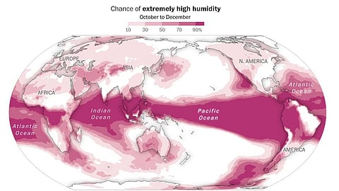
According to Noll, around 2.6 billion people worldwide could experience unusually high temperatures for the time of year through December. The high temperatures could be accompanied by dry conditions and droughts in several regions.
“Droughts are expected to continue in Central America, northern and southern South America and Indonesia,” Noll said.
“Extremely dry conditions are possible in the Pacific Northwest and Canada, parts of Africa, India, many South Pacific islands and northern and eastern New Zealand,” he added.
Noll also warned that extreme rainfall could affect around 1.3 billion people through December. Areas at risk include the southern and eastern US, large parts of South America, western and southern Europe, parts of Africa, the Middle East, central and eastern Asia and southern Australia.
“El Niño is firmly established and strengthening rapidly. WMO forecasts indicate a near-100 per cent likelihood that it will persist through February 2027, potentially being one of the strongest since at least 1950,” said Celeste Saulo, WMO secretary-general.
“El Niño doesn't add new heat to the planet. It releases heat the ocean has already been storing beneath the surface — which is why a strong event so often becomes one of the hottest years measured (as with 2024),” Saulo told the Global Heat Forum in Bangkok.
“The ocean it's drawing from is the warmest we've ever measured it. There is simply more heat available to release,” she said.
Noll also warned that the event could persist well into next year.
“This event is showing signs of potentially lingering longer into 2027, with El Niño's influence on the weather continuing through spring,” he wrote on X.