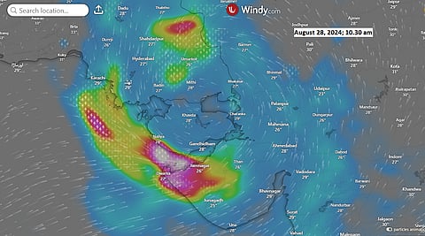

Gujarat and parts of Rajasthan are currently grappling with severe flooding caused by a land-based deep depression, which intensified over land and was exacerbated by moisture influx from the soils along its path from the Bay of Bengal and the Arabian Sea.
The flooding in Gujarat has claimed 15 lives and the India Meteorological Department (IMD) has predicted more rainfall over the next few days, with the entire state on red alert until August 29, 2024. On August 26, Gujarat received 91.3 millimetres (mm) of rainfall — 1,764 per cent more than normal, according to IMD data.
The arid regions of Saurashtra and Kutch experienced 95.2 mm of rain, an excess of 3,866 per cent. Sixteen out of Gujarat’s 36 districts received over 100 mm of absolute rainfall, while 20 districts recorded rainfall levels exceeding 1,000 per cent above the norm.
The highest rainfall of 206 mm was recorded in Morbi district, 9,264 per cent more than the average rainfall for the day. All this rainfall has been attributed to the deep depression.
A deep depression is a cyclonic system with wind speeds of 51-62 kilometres per hour (km/h), usually forming over the sea as a precursor to a tropical cyclone. However, its formation and intensification on land is rare. It is one notch below a tropical cyclone, which has wind speeds of 62-88 km/h.
The current system originated as a low-pressure area over the northwest Bay of Bengal on August 16, according to IMD data. It first tracked northward into Bangladesh and then westward into West Bengal.
By August 23, it was close to northeast Jharkhand and then moved swiftly to southeast Uttar Pradesh and northeast Madhya Pradesh, intensifying on land into a well-marked low-pressure area.
In the early hours of August 25, the system further intensified into a depression (with wind speeds of 31-50 km/h) over the usually dry areas of east Rajasthan and northwest Madhya Pradesh and then into a deep depression over east Rajasthan and west Madhya Pradesh by the morning of August 26, causing heavy rainfall and localised flooding in many areas.
As of the evening of August 27, the deep depression was positioned over north Gujarat, 100 km northeast of Kandla, according to the latest cyclone update from the IMD.
The rarity of the formation of a deep depression over land is due to the lack of abundant moisture required for the system to grow in size, generate winds, and accumulate rainfall, as compared to the sea. Only six land-based deep depressions have formed over India in the last decade, according to IMD data analysed by Down To Earth (DTE).
There have been two land-based deep depressions in the past month. The first system formed as a cyclonic circulation on July 31 over West Bengal and tracked up to Rajasthan, where it dissipated on August 6, causing flooding along its path.
While the first system moved in a westward direction, which is normal for such depressions during the monsoon, the second system has moved southwestward after its initial westward movement, which is rare.
“The formation of the deep depression is mainly due to abundant moisture supply from the Arabian Sea and also soil moisture plays a role in its intensification,” climate experts from the weather blog Vagaries of Weather told DTE.
“We have to be careful about the origins of the depressions because we see the depressions only when they begin to build up moisture and form cloud spirals. But the rotation may have started elsewhere, where convection or strong land heating over dry regions may have kicked off the low-pressure system,” Raghu Murtugudde, professor of climate studies at Indian Institute of Technology, Bombay and emeritus professor at the University of Maryland told DTE.
“The deeper question is how they (deep depressions) managed to get moisture supply. Was it recycling of soil moisture from earlier precipitation or was it shipped in from the oceans? Hard to say unless we do moisture transport calculations,” Murtugudde added.
The saturated soils along the deep depression’s path could have resulted from continuous bouts of excessive rainfall throughout the southwest monsoon season, especially in Gujarat and Rajasthan.
East Rajasthan has received 39 per cent excess rainfall during the monsoon season, while west Rajasthan has received 75 per cent more rainfall than normal. Saurashtra and Kutch regions together have received 50 per cent more rainfall than normal.
Firing up cyclonic circulation in dry, hot regions of the eastern regions should not be too surprising, according to Murtugudde. “Whether they die due to a lack of moisture availability or they deepen into moist systems depends on the history of rainfall in their path,” he said.
In a research paper published in the Journal of Climate of the American Meteorological Society in November 2017, scientists from the University of Reading demonstrated that both the direction of movement and the intensity of depressions formed during the monsoon season are dependent on the availability of pre-existing soil moisture.
Soil moisture aids the cyclonic system in penetrating deeper inland and gaining a structure similar to systems that form over the sea. These changes are also most significant when the storm system is deep rather than when it is weakening, as is the case with the extraordinary system currently affecting Gujarat.