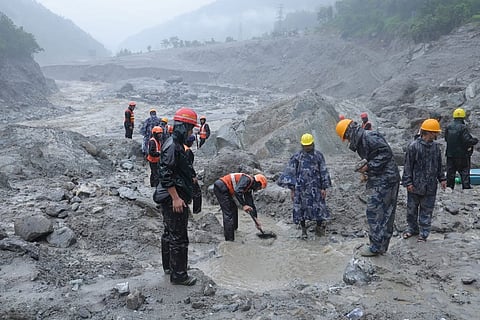


A catastrophic August 26 flood in Nepal’s Lhende Khola system unleashed energy greater than the Hiroshima atom bomb, according to geohazard expert Basanta Raj Adhikari.
Triggered by a massive glacier and rock collapse near Lirung Peak, the high-speed debris flow devastated valleys in Nepal and Tibet, killing hundreds, leaving thousands missing and destroying villages, roads and hydropower projects.
Basanta Raj Adhikari, director of Tribhuvan University’s Centre for Disaster Studies in the Nepali capital of Kathmandu is deeply alarmed by the sheer scale of the August 26, 2026, flash floods in Nepal, though not surprised given his research work tracking glacier melt. “It was highly unique and unprecedented in three distinct ways: its size, its area, and its mechanism,” said Adhikari who specialises in Himalayan geohazards and flood risk.
At about 8:40 a.m. on 26 August, a destructive wall of high-speed floodwater and debris, after entering the Lhende Khola river system, surged across ravines along the Nepal and Tibet border, overwhelming river valleys in Rasuwa district of Nepal and Tibet’s Gyirong County.
By August 29, the scale of the disaster became clearer with the confirmed death toll surpassing 650 while the number of people still missing approaching 2,500 on both sides of the Nepal-Tibet border as rescuers found it exceptionally difficult carry out rescue operations in affected areas were roads and bridges, needed for these operations, had suffered destruction.
The consequences of the flooding were amplified by the geography of the region. The Lhende Khola feeds into the Bhote Koshi and Trishuli river systems, providing a natural pathway for the surge to move rapidly from high mountain terrain into populated valleys. Villages, roads, bridges and hydropower installations were either swept away or buried under sediment.
Noting that “it is now clear”, Adhikari, in an interview with this writer, described the physical process of the disaster as an avalanche of ice and rocks rolling down in that area, traveling to the river, melting and transforming entirely into water, and then sending a massive surge downstream. He noted that this process is almost identical to the Chamoli glacier event in Uttarakhand, though this particular disaster occurred at a much higher altitude.
On February 7, 2021, a massive rock-and-ice avalanche of about 27 million cubic metres had collapsed from the north face of Ronti Peak in Chamoli in Uttarakhand. The mix of rock and glacier ice rapidly transformed into a high-speed debris flow that roared down the Rishiganga and Dhauliganga valleys, killing more than 200 people and destroying two major hydropower projects.
“In my research career,” said Adhikari, “I haven’t seen a bigger flood event than this in the Himalayan landscape,” considering the enormous energy created by coming down of huge amount of ice and debris. “I calculated the amount of energy, which is bigger than the atom bomb that happened in Hiroshima,” he said.
“This was an unprecedented event, and one that we had not previously imagined at this scale. We are relatively familiar with glacial lake outburst floods (GLOFs), but such a large-scale glacier collapse was not anticipated. The damage we have witnessed is beyond our expectations,” Dibas Shrestha, Assistant Professor, Central Department of Hydrology and Meteorology, Tribhuvan University, told this writer in an interview.
“It is now clear that the flash flood was triggered by the collapse of a huge hanging section of the glacier on the northern slope of the famous Lirung Peak in the Langtang Valley. The collapsed glacier mass vertically dropped of approximately 1,400 m,” he said and added: “However, we still do not know what caused the glacier to collapse in the first place. Several possible mechanisms need to be investigated, including unprecedented warming of the glacier bed, substantial accumulation of fresh snow, or the percolation of surface meltwater or small supraglacial lakes through the glacier, potentially reaching the bed and enhancing basal melting and instability. At this stage, we cannot identify the exact mechanism responsible for the collapse.”
The first indications of the August 26 Nepal flood event were somewhat misleading for members of the scientific community who found it challenging to analyse the footage that emerged from the affected regions. Seismic instruments used by the United States Geological Survey (USGS) registered signals that were initially interpreted as evidence of an earthquake. But subsequent analysis of seismic records and satellite observations indicated that the ground motion (magnitude 5.2) was generated by the glacial collapse and the ensuing debris flow.
Dan Shugar, a geomorphologist at the University of Calgary in Canada, was arguably the first scientist who created a buzz among the scientific community with his striking observations and assessments on social media shortly after the Nepal flooding event.
“It’s difficult to know with certainty but at the moment it appears that a piece of a glacier tongue broke off. But conservation of mass doesn’t easily let that relatively small piece turn into the horrific floods we’ve seen in the videos. So, it’s entirely plausible that another source is in play. One possibility is a larger rock avalanche from the same slope as the glacier. The challenge is that the satellite imagery so far is cloudy there,” he told this writer on the day the flood struck.
Rijan Bhakta, Head of Department, Department of Environmental Science, School of Science (Kathmandu University), said in an interview with this writer that while they have to wait for definitive empirical evidence, the massive magnitude of the event “was due to” impacts of climate change.
“Though it is monsoon season in Nepal, the country did not have much rain in the area, but the temperature was very high in the mountains,” he said and added: “High temperatures cause ice to melt. When a large volume of ice melts and comes down, it does not just bring ice but can also bring rocks with it which creates barricades impounds water. This has apparently formed a huge lake and has finally burst causing a huge volume of water to surge downstream at a massive speed.”
