

Nearly two weeks after the August 26 Nepal flood, investigators say a massive rock and glacier-ice collapse on Langtang Lirung triggered a cascading chain of hazards, forming new lakes and devastating valleys up to 100 km downstream.
Echoing the 2021 Chamoli disaster, the event exposes how climate-driven cryosphere instability and absent early warning systems leave Himalayan communities fatally exposed.
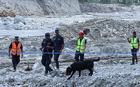
It has almost been a fortnight since the Nepal flood struck on the morning of August 26, and the disaster continues to reveal new dimensions. The event originated from the collapse of a mass of glacier ice and rock on the northern face of Langtang Lirung Peak (7225 m asl), triggering widespread devastation in the valleys below and the formation of two new lakes as part of a cascading hazard chain. The picture emerging so far is fairly clear: this was a steep rock failure (a breakoff) combined with an overriding mass of glacier ice, rather than a glacial lake outburst flood or an earthquake-triggered event. Some debate still remains, however, over whether the rockfall generated the seismic signal that was recorded, or whether a small earthquake helped trigger the rockfall itself. One encouraging aspect of the aftermath has been the speed with which researchers from around the world have mobilised to investigate the causes of this extraordinary disaster, arguably the largest cryosphere-related event the Himalaya has witnessed since the year 2000. On the same day, by late evening, satellite imagery from PlanetScope and Resourcesat-AWiFS began to reveal what had happened higher in the valley. Cloud-cover limited visibility until a Landsat 9 image became available, after which a clearer picture emerged. A subsequent drone survey exposed the scarp left behind in the affected zone, along with a newly formed lake near the point of impact. Modeling efforts are now underway to simulate the flood and reconstruct the chain of processes that led to this deadly event — one of the most significant in recent Himalayan history.
This event bears strong resemblance to the Raunthi Gad flood that struck Chamoli, Uttarakhand, on February 7, 2021, when a hanging glacier and an associated rock mass (roughly 0.28 km²) broke away near Raunthi Peak and fell from about 5,600 m to the valley floor at 1,800 m asl. That collapse triggered flooding in the Rishiganga and Dhauliganga rivers, killing more than 200 people and severely damaging two hydroelectric projects along with other infrastructure.
The Nepal event, in my assessment, differs in an important respect: rather than a hanging glacier, this appears to have involved a mountain glacier of roughly 5 km², with a steep, heavily crevassed ablation zone at its lower tongue. In this case, the combined mass of rock and overlying ice fell from an elevation of about 5,100 m down to roughly 3,700 m asl. Despite the shorter vertical drop compared to Chamoli, the scale of impact appears to be around four times greater — likely a consequence of the far larger volume of rock involved. The effects were felt roughly 100 km downstream from the source. Confirmed deaths currently stand at around 1,000, a number likely to rise, with several hundred more still missing. Numerous towns and villages along the Bhote Koshi and Trishuli rivers were affected, and many kilometres of roads and bridges were washed away. As with the Tapovan tunnel in the Chamoli disaster; an unknown number of workers are reported to be trapped inside the under-construction tunnel at the Chilime, Langtang hydropower sites.
Several questions remain unanswered: What triggered the rock collapse? Was it the inherent lithology and structural weakness of the slope, or an external factor — seismic activity, or human activity such as blasting for road, tunnel, or hydropower construction?
Where did the sheer volume of water come from? Was it simply the overlying ice, or did meltwater accumulate and pond for a period (possibly hours or even a day) before breaching and unleashing the flood, as some researchers suspect?
How fast was the flood moving? Estimates of the front velocity, derived from CCTV footage and hydrological station data, vary considerably between researchers and will need to be reconciled through further analysis.
The Himalaya is among the youngest mountain ranges, home to thousands of glaciers and lakes, a fragile ecosystem highly sensitive to climate change, and a landscape riddled with active tectonic faults and rock types prone to failure under even minor disturbance. As the climate continues to warm, glaciers are retreating and losing mass at an accelerating rate, forming new glacial lakes and exposing rock surfaces that were previously buried under ice. The daily cycle of melting and refreezing weakens this exposed rock through freeze-thaw action, a process further compounded by rising ground and land-surface temperatures.
Himalayan disasters, as a result, are rarely isolated events. They tend to unfold as complex chains of interconnected processes, set off by a variety of triggers, for example — extreme precipitation, seismic activity, or a rock or ice fall into a glacial lake in outburst floods. Understanding the region’s glaciers, glacial lakes, and permafrost and associated hazards requires close attention to the geology: local and regional lithology and structure, and the stability of the surrounding slopes.
Rasuwagadhi, situated on the Nepal-China border about 20 km downstream from the source of the disaster, was a major infrastructure hub — home to a hydropower project, an immigration office, a customs checkpoint, the Friendship (Maitri) Bridge, parking for roughly a thousand vehicles, and a commercial market. It was the first settlement struck by the flood. Despite its scale and modern infrastructure, the area had no early warning system in place, even though the region has long been known to be hazard prone.
Three kilometres further downstream, the village of Timure - built directly on the riverbed — was among the worst-affected locations, yet it too lacked any form of alarm system for a worst-case scenario like this one. As with the 2021 Raunthi Gad flood in Chamoli, no active warning system was operating at the time of the disaster. Had one been established, informed by the region’s history of past events, countless lives might have been saved. The lesson extends well beyond Nepal: the entire Himalayan region needs a robust, operational early warning system for cryosphere-related hazards
Views expressed are the author’s own and don’t necessarily reflect those of Down To Earth