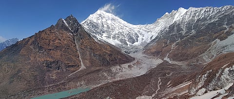


The devastating flood that struck Nepal’s Lhende-Bhotekoshi corridor in Rasuwa District on August 26,, 2026, was not simply another flood in the Himalayan region. Rather, it was a chain reaction of multiple events. The event began with a high-altitude glacier disturbance and rapidly developed into a destructive flood and debris-flow event downstream. The immediate cause of the event is still being investigated, and scientists are examining the roles of an ice-rock avalanche and the subsequent blockage and release of water in the Lhende river system. However, the larger significance of the disaster goes beyond the question of what exactly triggered the flood. The event highlights a broader problem in understanding Himalayan climate risk. A hazard that begins several kilometres upstream can rapidly change the behaviour of a river and affect communities, infrastructure and livelihoods far at the downstream. The disaster therefore needs to be understood as a cascading hazard, where different physical processes can interact and where the consequences of one event can create further risks to the downstream region.
This is not a completely new phenomenon in the Himalayan region. The region has experienced several disasters in which one hazard has triggered another. What is changing is the combination of a changing mountain environment with increasing human exposure in mountain valleys. The 2026 Nepal disaster gave another example of why risk assessment in the Himalaya needs to move beyond looking at individual hazards separately and to multi-hazard assessments. The history of Himalayan disasters has given important lessons in this regard, for example: one of the most well-known examples is the Dig Tsho glacial lake outburst flood in Nepal in 1985. On August 4, 1985, the moraine-dammed Dig Tsho lake suddenly released a large volume of water, and this water travelled downstream and caused extensive damage, including the destruction of the nearly completed Namche Small Hydroelectric Project. The event became an important example of the potential damage that a glacial lake outburst flood can cause to downstream infrastructure. The August 2, 2014, Jure landslide in Nepal demonstrated a different type of cascading hazard. A large landslide blocked the Sunkoshi River and created a temporary lake behind the landslide dam. This created the possibility of a much larger flood if the blockage failed. The event also affected roads, bridges and other infrastructure along an important transport corridor between Nepal and China. The disaster showed that the risk from a landslide does not end at the location where the slope fails, rather it starts when a landslide blocks a river, the river itself becomes part of the hazard process. The 2021 Melamchi disaster provided another example of how several processes can interact. An assessment by the International Centre for Integrated Mountain Development (ICIMOD) found that the disaster involved several processes operating at different locations, including rainfall, high-altitude processes, landslides, river damming, outburst flooding, erosion and debris deposition. The different processes interacted and increased the impact downstream. ICIMOD highlighted the need for a more integrated approach to multi-hazard risk management rather than assessing individual hazards separately. These events show that cascading hazards are not new in the Himalaya.
The 2025 and 2026 floods in the Lhende river system provide a particularly important example because they involved different cryospheric processes within the same broader mountain environment. On July 8, 2025, about 35 kilometres upstream from the Nepal-China border, a supraglacial lake on Tibet’s Purepu Glacier rapidly drained, causing a flash flood. The National Disaster Risk Reduction and Management Authority (NDRRMA) of the Government of Nepal reports that the flood caused significant damage downstream as it moved along the Lhende river, also referred to as the Bhotekoshi river in Nepal. Roads, bridges, hydroelectric plants, and the Rasuwagadhi dry port were all impacted by the catastrophe. The NDRRMA report also used satellite observations to investigate the source of the flood. Sentinel-2 imagery showed that supraglacial ponds began forming on the Purepu Glacier in March 2025 and expanded during the following months. By July 7, the combined lake area had reached approximately 0.75 square kilometres. On July 8, the lake area had decreased sharply and drainage features were visible on the glacier surface. These observations supported the conclusion that rapid drainage of the supraglacial lake contributed to the downstream flood.
The contrast between the different cryospheric processes affecting the same Lhende river system in 2025 and 2026 is particularly important for understanding Himalayan risk. In July 2025, the flood was associated with the rapid drainage of a supraglacial lake on Tibet’s Purepu Glacier, around 35 kilometres upstream from the Nepal-China border. Satellite observations documented the development and expansion of supraglacial ponds on the glacier before the event, followed by a sharp reduction in lake area and visible drainage features on July 8. The resulting flood travelled downstream through the Lhende river system and affected roads, bridges, hydropower facilities and the Rasuwagadhi dry port. In August 2026, the situation was different. Scientists investigated an ice-rock avalanche in the high-altitude Lhende Khola area as a possible trigger, with evidence suggesting that the river was temporarily blocked before the flood wave moved downstream. The immediate sequence is still being investigated, but the two events clearly point to different physical processes producing destructive flooding within the same broader river environment. This difference matters because it shows that a river corridor can remain exposed even when the specific hazard identified in an earlier event is different. After the 2025 flood, attention to glacial lakes and their potential drainage is important, but monitoring only glacial lakes would not necessarily identify an unstable ice-rock slope or a sudden river blockage. Similarly, a flood-warning system that depends mainly on rainfall and river-level changes may have limited lead time when the process begins suddenly at high altitude. The 2025 and 2026 events therefore show the need to look at the entire upstream-to-downstream hazard pathway, rather than treating each hazard as a separate event. A change in a glacier, an unstable slope, a river blockage or a sudden release of water can all alter the behaviour of the same river and create consequences farther downstream. This has direct implications for infrastructure planning in the Himalayan region. The same corridor contains communities, roads, bridges, hydropower facilities and important border and trade infrastructure, meaning that the consequences of a mountain hazard extend beyond the location where it begins. Infrastructure assessments should therefore consider not only whether a project is exposed to a conventional flood, but also whether an upstream glacier, ice-rock slope, landslide or temporary river blockage could generate a flood or debris flow capable of reaching the project. Historical flood records remain useful, but they cannot capture every possible mechanism through which water and debris can move through a mountain catchment. The two Lhende events provide a clear example: the hazard mechanism changed, but the downstream exposure remained.
The transboundary nature of the Lhende-Bhotekoshi system makes this more complicated. The 2025 event originated on the Tibetan side before its impacts were felt downstream in Nepal, while the suspected process in 2026 was associated with the high-altitude Lhende Khola area. This means that understanding risk requires information from different parts of the river system and, in some cases, across national boundaries. Monitoring of glaciers and slopes, river discharge, snow and ice conditions, rainfall and potential blockages needs to be connected with rapid communication to downstream communities and infrastructure managers. The lesson from these two events is therefore not simply that the Himalaya is experiencing more floods. Infrastructure planning and early-warning systems must be for the variety of potential risks that can arise from various cryospheric processes within the same interconnected river system.
Views expressed are the author’s own and don’t necessarily reflect those of Down To Earth