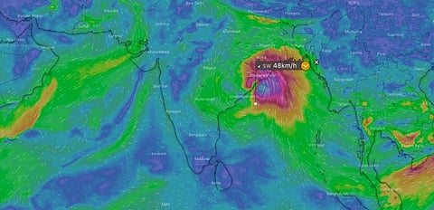

A low pressure area predicted to form over the Andaman Sea in the next few days might intensify into the current cyclone season’s first cyclone, according to the weather visualisation website windy.com.
The India Meteorological Department (IMD) has also indicated the formation of a low pressure area November 29, 2021. The system was likely to become more marked and move in a west-northwestward direction, it added but did not give details about its further intensification.
Windy.com, based out of the Czech Republic, analyses raw data from the Global Forecasting System (GFS) model of the United States, the European Centre for Medium Range Weather Forecasts (ECMWF) model and the Icosahedral Nonhydrostatic (ICON) model of the German Weather Service.
It generates hyper-granular forecasts and assessments of global weather conditions — from fundamental parameters like temperature, wind speed, wind direction, rainfall and cloud cover to additional parameters such as fire risk, air pollution and dew point.
In a world rife with the changes wrought by global warming, the forecasts generated from the various datasets sometimes do not match.
Take for instance, the current case of cyclone formation. GFS data November 25 showed that the system may move in a generally northwestward direction to begin with, but might curve eastwards from the central Bay of Bengal around December 3.
It further showed that the system might move close to the Odisha and West Bengal coasts December 4. GFS data showed the system moving closer to the Odisha and Andhra coasts December 5 on the morning of November 26.
The ECMWF data, on the other hand, showed November 25 that the low pressure system might make a more eastward turn in the central Bay of Bengal December 3 and then move straight towards the West Bengal and Bangladesh coasts December 4.
The ECMWF data agreed with the GFS model on the morning of November 26 and showed the system close to the Odisha and Andhra coasts December 5.
The cyclone, if and when it forms, would be named ‘Jawad’.
All this information needs to be taken with caution because of the uncertainty.
The models have predicted the formation of cyclone Jawad, often picked up and reported by media outlets, for a couple of months now but it has eluded the Indian coasts this season.
October and November, which are the peak cyclone months, will likely remain cyclone-less this year, for the first time in the last three decades.
Experts have cited that the major reason behind this could be the late withdrawal of the southwest monsoon this year and the improper formation of the northeast monsoon.
This disruption of the winds above sea surfaces around the country could have created conditions not conducive for cyclone formation.
The formation of a slew of low-pressure areas since September, which has caused strife in the form of extreme rainfall and floods in many south Indian states, might also have dissipated energy above the sea surfaces, limiting the formation of a cyclone.