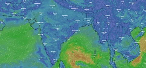

A cyclone may impact the Tamil Nadu and Puducherry coasts from December 8 onwards. The exact intensity of the cyclone is unclear right now but it looks like the storm system may move rather slowly over the Bay of Bengal sea just off the coast of Tamil Nadu for a couple of days before making landfall.
Slow-moving cyclones often absorb a lot of moisture, carry humongous amount of rainfall and gain strength in the form of wind speeds. The cyclone will be called ‘Mandous’. The name has been suggested by the United Arab Emirates.
A low pressure area formed over the south Andaman Sea on the morning of December 5, 2022 and intensified into a well-marked low pressure area on the morning of December 6, according to the India Meteorological Department’s (IMD) latest cyclone update.
The weather agency predicted that the storm system may move in the west and northwestward directions and intensify into a depression by the evening of December 6.
It may subsequently strengthen further into a cyclone over southwest Bay of Bengal and move towards the Tamil Nadu and Puducherry coasts by the morning of December 8.
It will start affecting the coast with wind speeds of 40-50 km/hr, gusting to 60 km/hr from the morning of December 8. This could intensify to 50-60 km/hr, with gusts of up to 70 km/hr, by the evening of the same day.
The maximum wind speeds along the coast may increase to around 70-80 km/hr, with gusts of up to 90 km/hr from the evening of December 9 to the morning of December 10. After this, IMD predicts that the wind speeds would come down to 40-50 km/hr by the night of December 10.
Data from the European Centre for Medium Range Weather Forecasting (ECMWF) and the Global Forecasting System (GFS) of the United States as forecasted and represented on the weather visualisation website windy.com showed that the system is moving quite slowly after its intensification into a cyclone from the morning of December 8 to the morning of December 10.
“The storm system does seem to be moving sluggishly over the south west Bay of Bengal before it moves to the coast of Tamil Nadu,” Akshay Deoras, research scientist at the National Centre for Atmospheric Science & Department of Meteorology, University of Reading, UK, told Down To Earth.
“The reason for this could be a high pressure system over Thailand and the south Andaman Sea which has created a change in the steering environment of the cyclonic system,” he added.
Steering environment is constituted by the winds around the cyclone that help in its movement and aid in its intensification or de-intensification.
The data from GFS and ECMWF also currently show that cyclone would de-intensify before it makes landfall and Deoras agreed on this.
IMD’s current forecast of the cyclone also shows de-intensification. Cooler sea surface temperatures closer to the coast of Tamil Nadu and the unfavourable conditions could be responsible for this de-intensification, according to Deoras.
The IMD has not indicated the amount of rainfall that the cyclone could carry but it has warned of extremely heavy rainfall in isolated places in north coastal Tamil Nadu, Puducherry and south coastal Andhra Pradesh on December 9.
It has also forecast isolated heavy to very heavy rainfall in north interior Tamil Nadu and the Rayalaseema region of Andhra Pradesh. Heavy to very heavy rainfall is also predicted for north Tamil Nadu, Rayalaseema and south Andhra Pradesh on December 10.
Deoras predicted that the cyclone may cause as much as 200 mm of rainfall along the coast of Tamil Nadu and 100-200 mm of rainfall in interior Tamil Nadu.
There is also a chance for the storm system crossing over to the Arabian Sea but “it is too soon to be able to say if it will re-intensify into another cyclone,” Deoras said.