Mandous is now headed to Karnataka, where it could bring substantial rainfall
A fallen tree being cleared from Arcot Road in Chennai. Photo: @chennaicorp / Twitter
Cyclone Mandous made landfall on the Tamil Nadu coast in the early hours of December 10, 2022, according to weather agencies. It is now heading to Karnataka.
The India Meterological Department (IMD) tweeted that Mandous had crossed the coast at about 1.35 am IST near Mamallapuram.
Cyclonic storm ‘Mandous’ crossed coast close to Mamallapuram and lay centred at 0130 IST of today (10.12.2022)near 12.7°N / 80.1°E,northwest of Mamallapuram. Rear sector of the cyclone is moving towards land and hence the landfall process will be completed in the next one hour.
— Tamilnadu Weather-IMD (@ChennaiRmc) December 9, 2022
Pradeep John, who tweets about weather in Tamil Nadu, said the winds due to Mandous were the strongest since Cyclone Vardah in 2016.
“One edge of the cyclone has almost started to touch the land. Strongest wind speed in Chennai since Vardah. Many stations have crossed 100 mm rainfall from 8.30 am and if we take from yesterday night it is 175 to 200 mm rain in Chennai City,” John tweeted at 11.18 pm December 9.
The cyclone caused water-logging and subsequent traffic disruptions in Chennai.
Condition of Chennai Annasalai GP Road. What happened to Chennai Rainwater drain project ? #CycloneMandous pic.twitter.com/FOOqP1zBhF
— G Pradeep (@pradeep_gee) December 9, 2022
The civic authorities stopped the flow of traffic in certain stretches:
In view of the Mandous cyclone, Traffic is not allowed bothways on Kamarajar saalai between Gandhi Statue and Napier bridge except for the residents living in this stretch and emergency services vehicles till further notice. Road users are requested to use RK Saalai - Anna Saalai pic.twitter.com/uJtmALTU58
— Greater Chennai Traffic Police (@ChennaiTraffic) December 9, 2022
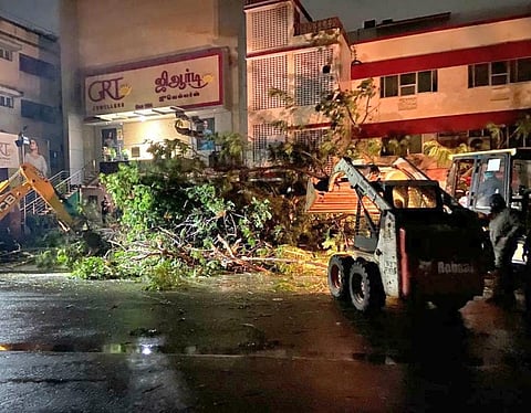
The Greater Chennai Corporation also tweeted several photos of its personnel working through the night, clearing fallen trees from key roads.
A satellite image shared by IMD showing Mandous making its way inland.
Mandous is now headed to Karnataka, where it could bring substantial rainfall according to Akshay Deoras, a research scientist at the National Centre for Atmospheric Science & Department of Meteorology, University of Reading, UK.
#CycloneMandous made landfall to the south of Chennai around 2 am IST. It's now heading towards Karnataka as a weak low-pressure system that would still produce substantial rainfall over the state. pic.twitter.com/51nmrO6BW0
— Dr Akshay Deoras (@akshaydeoras) December 9, 2022
We are a voice to you; you have been a support to us. Together we build journalism that is independent, credible and fearless. You can further help us by making a donation. This will mean a lot for our ability to bring you news, perspectives and analysis from the ground so that we can make change together.
Comments are moderated and will be published only after the site moderator’s approval. Please use a genuine email ID and provide your name. Selected comments may also be used in the ‘Letters’ section of the Down To Earth print edition.