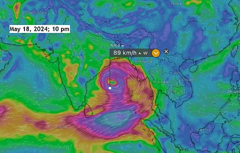

The first cyclone of the pre-monsoon season for 2024 may be brewing in the Bay of Bengal even as the India Meteorological Department (IMD) puts Kerala and Tamil Nadu on red alert for extreme rainfall on May 19 and May 20 due to multiple land-based cyclonic circulations and low-pressure systems over the region.
The cyclone may become severe due to the extremely warm sea-surface temperatures in the Bay of Bengal over the past few months. The IMD has not yet issued a cyclone alert.
Wind speed in the Bay of Bengal. Screengrab: Earth Null School
The weather visualisation website Windy.com on May 19 shows the formation of a low-pressure area on May 21, which is expected to intensify to cyclone strength on May 22. The cyclone may attain wind speeds close to 90 kilometres per hour on May 23.
Predicting the wind speeds and track of the cyclone at this early stage is difficult, as cyclones have displayed unpredictable behaviour in the past few years.
The sea-surface temperature tracking website Seatemperature, which accesses data from national meteorological centres, reported that the maximum sea-surface temperature of the Bay of Bengal is currently 32.5 degrees Celsius, the minimum is around 29.2°C and the average is around 30.7°C.
Sea-surface temperature of the Bay of Bengal. Screengrab: Windy.com
Low-pressure areas that intensify into cyclones need sea-surface temperatures to be around 27°C-28°C to form, and Windy.com showed that the sea-surface temperatures may remain around 30°C.
In the case of many pre-monsoon cyclones, high sea-surface temperatures have played a role in making them intense. This was the case with Cyclone Amphan in May 2020.
When the cyclone was active over the Bay of Bengal, sea-surface temperatures were as high as 32°C-34°C, which led to its rapid intensification (RI). RI occurs when there is an increase in the maximum sustained winds of a cyclone by at least 55 km/hr within 24 hours.
Many north Indian Ocean cyclones, as well as hurricanes and typhoons in other ocean basins, have been undergoing RI in the past few years, mainly due to warmer than normal sea-surface temperatures. This trend has made it challenging for national meteorological organisations to track and forecast the behaviour of these storm systems accurately.
Apart from sea-surface temperatures, the other ingredients needed for the genesis and intensification of a cyclone are moisture and weak vertical shear winds. These factors contribute significantly to the development and strengthening of cyclonic systems by providing the necessary atmospheric conditions for their formation and growth.
Vertical shear winds are upwardly mobile winds surrounding a cyclone. When these winds become strong, they can disrupt the structure of a cyclone, potentially leading to its dissipation. The IMD will begin tracking these parameters as the low-pressure area forms in the Bay of Bengal, as they play a crucial role in determining the intensity and longevity of cyclonic systems.