
Subscribe

Nigeria, where about 35 per cent of the total land area was affected by desertification by 2015, has rehabilitated over 1,558.62 hectare (ha) of degraded land and lifted more than 8,000 people out of poverty, through a World Bank project aimed at reducing vulnerability to soil erosion.
The programme NEWMAP (Nigeria Erosion and Watershed Management Project) — an eight-year intervention project launched in 2015 with the help of World Bank — has shown the way in reversing land degradation, focusing on major gully erosion sites, said Salisu Dahiru, national coordinator of the project.
He was speaking during a side event at the the United Nations Convention to Combat Desertification’s (UNCCD) 14th session of the Conference of Parties (CoP14) on September 4, 2019.
The NEWMAP programme has three operational components:
The gully restoration component was designed in parallel with catchment planning, soil and water conservation, as well as livelihood enhancement activities such as grants to community members to implement selected community sub-projects. This generated income and/or provided skills that lead to employment opportunities or new start-ups, according to Dahiru.
“The project supported over 5,159 beneficiaries via grants. The people are now engaged in businesses such as livestock farming, small shops, trading, and honey production, etc,” he said.
To ensure sustainability, NEWMAP established soil and water conservation zones that communities will directly contribute to reducing erosion while conserving biodiversity and supporting sustainable forest management.
Nigeria, known for the highest rate of deforestation in the world, had between 50 per cent and 75 per cent of the land mass in 11 northern Nigerian states under desertification in 2015.
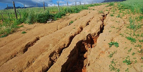
As a result of the extreme land degradation, there was formation of gullies and ravines, particularly in southeastern parts of the country. These gullies are the largest ecological challenge that the region is experiencing, Dahiru said.
“Some of these gullies can be as deep as 100 metres and as wide as 20 to 30 metres and could stretch over several kilometres,” Dahiru said.
“We consider these as end results of prolonged land degradation resulted mainly from the loss of vegetation cover and leading in loss of livelihood because majority of population is in and around the area where these gullies exist. So restoring this land has been of prime most importance to us and the community and the World Bank came to the rescue,” he added.
The second phase of the project would focus on the restoration of 10 new flood and gully erosion sites.