
Subscribe

Globally, tropical cyclones — also known as hurricanes, typhoons or simply cyclones, depending on the ocean basin in which they form — have been predicted with great precision by national and regional weather agencies.
India Meteorological Department (IMD) has also gained formidable expertise in predicting these systems in the north Indian Ocean region. However, the unprecedented warming of the oceans and the lack of certain types of data have recently made it challenging to predict the track, wind speeds and accompanying rainfall for cyclones in all ocean basins and to provide early warnings for the impacted people.
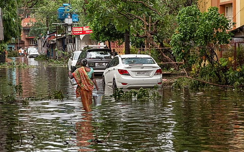
Since the 1999 super cyclone that hit the eastern coastal state of Odisha and killed around 10,000 people, IMD has made significant advances in its cyclone monitoring and forecasting, which has brought down the loss of lives to next to none in the past few years.
Read more: There are no ‘natural disasters’
Even so, warming oceans mean that these storm systems now exhibit new characteristics. In 2023 alone, all ocean basins experienced unprecedented levels of warming and marine heatwaves. Oceans have broken their average sea surface temperature records for 13 consecutive months. With every degree Celsius rise in global atmospheric temperatures, moisture levels increase by 7 per cent.
The warmth and moisture lead to the origin of cyclones and fuel their intensification. One new characteristic of tropical cyclones that climate scientists have observed in recent years is rapid intensification (RI). RI occurs when a tropical cyclone gains wind speeds of more than 55 kilometres per hour within a 24-hour period.
Many recent cyclones, hurricanes and typhoons are undergoing RI compared with earlier. For instance, typhoon Bolaven, which formed in the west Pacific Ocean on October 7, 2023, rapidly intensified from a category 1 storm to a category 5 storm in just 12 hours.
Cyclone Freddy, which impacted Madagascar, Mozambique and Malawi in March 2023, became the first tropical cyclone to experience seven phases of RI over a period of 37 days, setting a new record.
Freddy also broke the record for accumulated cyclone energy (ACE). ACE is the total wind energy generated by a tropical cyclone throughout its lifetime, calculated as the square of the peak wind speed, observed, calculated and added every six hours.
After travelling for more than 7,000 km from the northern coast of Australia to the southeastern coast of Madagascar over a period of 15 days, the cyclone engaged in a unique back-and-forth pattern between the coasts of Madagascar and Mozambique. It then followed a zigzag course over Mozambique, Zimbabwe, Zambia and Malawi.
This occurred over a period of 22 days — from February 21 to March 15, 2023 — during which the storm wreaked havoc in Madagascar, Mozambique and Malawi, bringing torrents of rain and swift winds to some parts of Zambia and Zimbabwe.
The multiple RIs and the bouncing back and forth of Freddy were not predicted. In fact, none of the national meteorological agencies around the world are currently able to detect and accurately forecast rapid intensification even a day in advance.
“Such record breaking and unique characteristics were observed in cyclone Freddy due to warmer-than-normal sea-surface temperatures and also warmer-than-normal sea-subsurface temperatures,” Roxy Mathew Koll, a climate scientist from the Indian Institute of Tropical Meteorology, Pune, told Down To Earth.
Such RIs have also been witnessed in the case of cyclones in the north Indian Ocean region, such as in the case of super cyclone Amphan in May 2020.
The difficulty also arises from a lack of data. “Across the world’s ocean basins, the measurement of subsurface temperatures is not done very well right now and this is one of the gaps in data and understanding that we have,” Koll said.
While sea-surface temperatures can be monitored using satellites, subsurface temperature data needs to be obtained from surface monitoring using ocean monitoring instruments such as buoys and moorings.
“We also need to understand how these subsurface temperatures are evolving over time to be able to make better predictions. And this is not happening right now,” said Koll.
In fact, India lost many of its own buoys and moorings over the last few years due to the COVID-19 pandemic, according to Koll. These instruments, whose data is monitored by Indian National Centre for Ocean Information Services (INCOIS) based in Hyderabad, provide data on sea surface and subsurface temperatures, which are essential for accurately predicting characteristics like RIs.
RI is closely tied to the sea surface and subsurface temperatures. “These instruments need to be serviced every year or so. During the pandemic, the maintenance could not be carried out, so we lost most of them. Some of them were not serviced for more than three years,” said Koll.
Another aspect of cyclone forecasting is accurately predicting the track of the cyclone, particularly the location where it could make landfall and the potential impact of the cyclone’s winds, rainfall and storm surge along the coast.
“Even though IMD has mastered the art of making accurate forecasts of where a particular cyclone would make landfall, sometimes slips happen,” said Koll.
Two main reasons can lead to inaccuracies in cyclone forecasts: when a cyclone forms near the monsoon season, which brings a lot of atmospheric complexity to India and when the cyclone’s structure is disorganised.
If a cyclone forms from the lower troposphere (the lowest layer of the atmosphere) to the upper troposphere, then it is well organised and easier to forecast. This is because winds in the upper troposphere are stronger and exert control over the cyclone’s structure, making it stable, according to Koll.
When the cyclone forms from the lower to middle troposphere, it is not well organised and therefore quite difficult to predict. This is because winds in the middle troposphere are not as strong.
To make accurate forecasts of cyclones and generate useful early warnings in a particular region, data from all the countries in that region need to be brought together and fed into the weather models. Additionally, weather data from exclusive economic zones is currently unavailable, creating another data gap.
As these zones are predominantly situated near the coast, data from them is crucial for modelling interactions between land, atmosphere and sea.
“That is why India needs to scale up its cooperation with its neighbouring countries to expand its database with data on sea surface and subsurface temperatures from buoys, moorings and exclusive economic zones as well,” said Koll.
This would assist IMD in providing improved forecasting for India and neighbouring countries, as was the case with cyclone Mocha that struck Myanmar in May 2023.
IMD forecasts of the cyclone helped the country take evasive action on the ground, according to Koll. Capacity needs to be developed in these countries for better data collection and financing for programmes to accomplish this needs to be provided.