
Subscribe

Six tropical storms are whirling around in the Atlantic and the Pacific all at once, in what is being said to be very unusual hurricane activity.
“They are forming like roaches out there,” is how Eric Blake, forecaster at the National Hurricane Centre (NHC) described the storms.
The six storms are named Humberto, Kiko, Jerry, Mario, Imelda, and Lorena. According to the NHC, Imelda, which flooded parts of Texas on September 19, 2019, was weakening on September 20, leaving five active storms currently.
The combined number of active storms has reportedly tied a modern record, set in September 1992, Blake tweeted.
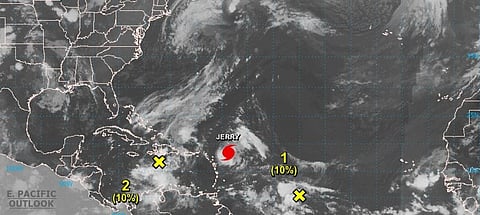
In the Atlantic, Tropical Storm (TS) Jerry, located a few hundred miles east of the Leeward Islands, has strengthened to a hurricane and is moving west-northwest at a speed of 16 miles per hour (26 km/h). It is expected to produce heavy rains over the northern Leeward Islands as it passes to the north of that area later on September 20 and could move near Bermuda next week, said a forecast by NHC.
A gradual weakening trend is forecast to begin on September 20 but Jerry is expected to remain a hurricane during the next few days.
Humberto, which has become an extratropical cyclone, will continue to affect Bermuda, the north-western Bahamas and the east coast of the United States during the next couple of days. It is moving north-northeast at 20 mph (31 km/h). A turn toward the east-northeast is expected to commence by September 20 night and a gradual weakening is expected during the next couple of days.
Large swells and dangerous surf generated by Humberto will continue along the coast of Bermuda during the next day or two, and these could continue to cause coastal flooding. Swells will continue to affect the northwestern Bahamas and much of the coast of the United States from east-central Florida to the Mid-Atlantic States during the next couple of days.
In the Eastern Pacific, Tropical Storm Lorena, which is near hurricane strength, is expected to bring heavy rainfall to the far southern Baja California Sur in Mexico on September 21, with possible flash flooding. A hurricane warning has been issued for the area.
While Mario is moving on slowly north-north eastward, TS Kiko is going to linger for several more days.
Moreover, two disturbances in the form of tropical waves are producing disorganised showers and thunderstorms and have a 10 per cent chance of forming into a cyclone in the next 48 hours.
September is the peak month for hurricane and tropical storm activity especially in the Atlantic basin as the combination of warm sea surface temperatures, low vertical wind shear and a pre-existing disturbance, create the perfect conditions for a hurricane.
From 1975 to 2017, there has been an average of 3.1 Atlantic hurricanes per year in September, said National Oceanic and Atmospheric Administration.
Meanwhile, another Tropical Storm Tapah is expected to bring rain to all of Taiwan from September 20 to 21.