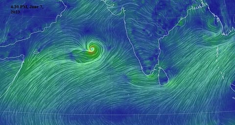

Cyclone Biporjoy as seen in this Earthnull School grab
The India Meteorological Department (IMD) announced that Cyclone Biporjoy, which developed into a very severe cyclonic storm at 11.30 pm on June 7, over the Arabian Sea, is likely to influence the monsoon progress.
The onset of the southwest monsoon, which typically lasts from June-September, has been delayed this year. It typically sets in Kerala on June 1 and covers the entire country by July 15.
During this particular cyclone, monsoon onset might be delayed and weak, experts told Down To Earth (DTE).
“Westerly winds, which pull the monsoon towards the Indian mainland, are weak now. All the moisture is rotating around the cyclone,” Mahesh Palawat, vice president of Meteorology & Climate Change at Skymet Weather Services Pvt Ltd, told DTE.
Rainfall, he said, will be weak over peninsular India and several parts of the country.
IMD says the conditions are becoming conducive for the onset of the monsoon. There are westerly winds over the south Arabian Sea and there is an increase in the depth of westerly winds up to middle tropospheric levels and an increase in cloudiness over areas covering the southeast Arabian Sea, Lakshadweep and Kerala coasts. These signs indicate an onset in Kerala over the next 48 hours.
Some cyclones in the Arabian Sea have formed during the onset phase of the Indian Summer Monsoon.
Such a situation arose in 1984, 1985, 1987, 1988, 1989, 1992, 1994, 1996, 1998, 2001, 2007, 2010, 2011, 2014, 2015, 2018 and 2019 between 1979 and 2019. This is 17 years out of 41, showed the paper.
About 70 per cent of tropical cyclones and 90 per cent of the very severe and super cyclones over the Arabian Sea strike during May, June and November, according to a 2021 paper.
Cyclones and the monsoon impact each other. “A cyclone cannot form if we have a strong monsoon,” Roxy Mathew Koll, a climate scientist at the Indian Institute of Tropical Meteorology (IITM) in Pune told DTE.
A weak onset of monsoon results in the formation of a cyclone.
If the southwest monsoon current is strong, according to Koll, winds blow in two directions — southwest in lower levels and northeast in upper levels. This prevents the cyclone from rising vertically, hindering its formation.
This time the monsoon is weak, allowing the cyclone to develop vertically as it can pass through the winds and move upwards, he explained.
The reason for the weak onset is not clear. It could be El Nino, the warm phase of a recurring climate pattern across the tropical Pacific. Indian Ocean warming due to climate change could also be playing a role, Koll explained.
Once a cyclone is formed, it can further influence the monsoon, depending on the direction of its track. It could either enhance or hamper it, according to the expert.
If it is moving away from the mainland, it is driving the moisture away. But if it is progressing towards the coast, it could enhance monsoon.
For instance, Cyclone Nisarga helped the progression of the monsoon since it moved towards the subcontinent along with the monsoon, Koll explained.
The progression of the monsoon this year could be weak till the cyclone fades away. It could get stronger thereafter. “Other factors such as El Nino can influence its progression. It is too early to forecast this,” Koll noted.
La Nina persisted for three years before ending in 2023. There is a 60 per cent chance for an El Nino during May-July 2023, according to the World Meteorological Organization.
Biparjoy showed rapid intensification — a depression, deep depression and cyclone formed on the same day, June 6, 2023.
A severe cyclonic storm developed at 5.30 am and it progressed to a very severe cyclonic storm within a few hours at 11.30 am on June 7, 2023.
Cyclone Biporjoy is the second most intense rapid intensification by a north Indian Ocean cyclone that formed in June. It holds the 2nd position jointly with Cyclone Vayu, Vineet Kumar, Senior Research Fellow, Centre for Climate Change Research, IITM, wrote on Twitter.
“In the recent past, we are seeing cyclones rapidly intensify due to warm ocean conditions. This trend has emerged in the last decade or so,” Koll said.
The cyclone is likely to move nearly northwards during the next 24 hours and then north-northwestwards thereafter, IMD stated.
The European Centre for Medium-Range Weather Forecasts or ECMWF model as visualised by the software Windy shows that the system is moving towards Gujarat. On June 6, it was moving towards Pakistan.
“The European model is showing that the system is recurving towards Gujarat. So we may need to wait to be certain,” Koll said.
Another weather forecast model, Global Forecast System or GFS, predicts a different track. Data visualised by Windy shows that it will likely make landfall in Oman on June 14.