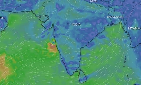

The Southwest Monsoon (SWM) season is ready to make an early and strong onset over Kerala one week in advance, but its future progress remains uncertain. The uncertainty stems from the formation of twin cyclonic systems in the Arabian Sea and the Bay of Bengal which could lead to stalling of monsoon winds, something that has happened in the past as well.
On May 21, the India Meteorological Department (IMD) stated in a press release that the SWM “advanced over some more parts of south Arabian Sea, Maldives & Comorin area; South Bay of Bengal; some more parts of central Bay of Bengal and some parts of northeast Bay of Bengal.”
The weather agency predicted that the monsoon winds could onset over Kerala in the next three to four days which would mean that the beginning of the primary rainfall season for most regions in India starts one week earlier than the normal date of June 1.
“The conditions are also likely to become favourable for further advance of southwest Monsoon over some more parts of South Arabian Sea, remaining parts of Maldives and Comorin area; some parts of Lakshadweep area, Kerala, Tamil Nadu; some more parts South & Central Bay of Bengal, North Bay of Bengal and some parts of Northeastern states during the same period,” according to the IMD.
The IMD has earlier predicted above normal or excess rains during the entire monsoon season and an onset over Kerala around May 27.
Around the same time as the monsoon winds arrive over Kerala, multiple low-pressure systems are also going to be active in the North Indian Ocean region on either side of the country’s landmass.
The IMD indicated the presence of an upper air cyclonic circulation over east-central Arabian Sea just off Karnataka-Goa coasts in the early morning hours of May 21. This system could induce the development of a low pressure area over the same region by the evening of May 21.
“It is likely to move nearly northwards and intensify further into a depression during subsequent 36 hours,” writes IMD in its press release. The weather analysis and visualisation platform windy.com, using data from the United States (US) Global Forecasting System (GFS), shows that the depression may hover over the sea just off the coast of Maharashtra, close to Mumbai.
The European Centre for Medium-range Weather Forecasts (ECMWF) model visualised on windy.com shows a less intense system cross over to land in the early morning hours of May 23 and move towards Pune city. In either case, the system could bring heavy rainfall for the Konkan coast and some inland areas in Maharashtra and Gujarat as well.
The IMD had predicted extremely heavy rainfall for Konkan and Goa for May 21. Goa received 94.5 mm of absolute rainfall on May 21 which was 2,601 per cent in excess of the normal rainfall for the date. South Goa received 108 mm which was 3,078 per cent more than the normal.
Among coastal Maharashtra districts, Sindhudurg recorded the highest — 56 millimetres (mm) — volume of rain which was higher than the normal by 4,210 percent. These rainfall totals and excess show that monsoon-like rainfall is already occurring in many parts of the western coast of India.
IMD has predicted heavy to very heavy rainfall in the region for May 22 to May 24 and heavy rainfall till May 27. Heavy to very heavy rainfall has also been predicted for Madhya Maharashtra, Marathwada and Gujarat on many days till May 25.
GFS data, as visualised by windy.com on May 22, shows the formation of a low-pressure area in the Bay of Bengal close to the Andaman Sea on May 26 and its subsequent intensification and movement towards the Odisha coast around May 29. GFS also shows a simultaneous development of a low-pressure system in the Arabian Sea on May 29.
ECMWF data on windy.com, on the other hand, shows the formation of a weak low-pressure area in the northernmost parts of the Bay of Bengal on May 28. The European model shows that the earlier low-pressure system in the Arabian Sea would continue to affect inland areas till May 29-30.
The disagreement of the two models shows that the formation, progression and intensities of these low pressure systems is still uncertain and needs to be watched closely. Many private weather forecasters have highlighted the early and strong onset of SWM based on these models. But future progress still remains uncertain.
“As usual, a cyclone can pull the monsoon trough forward and favour an early onset depending on its location,” Raghu Murtugudde, professor of climate studies at the Indian Institute of Technology, Bombay and emeritus professor at the University of Maryland, told Down To Earth.
“Southwesterly winds are already in place. So, we have to see what the Arabian Sea low-pressure system will do,” he added.
“We were already expecting an onset by a few days before June 1. But it’s all within a week of June 1. So, I wouldn’t claim them to be early onsets unless the trough continues to march forward faster than normal also. Let’s hope that the cyclone doesn’t end up stalling the trough after the onset,” Murtugudde explained.
Such stalling of monsoon winds after an early and sometimes strong onset has been observed before. In 2024, after an early and a rare simultaneous onset of monsoon over Kerala and the Northeastern states, the Bay of Bengal branch of the monsoon stalled for at least 19 days.
The stalling occurred because of the formation and movement of Cyclone Remal over the Bay of Bengal. It led to higher-than-normal day and nighttime temperatures across many states of India and even heat waves in some regions.
A similar early onset and stalling had also occurred in 2021 when Cyclone Tauktae in the Arabian Sea and Cyclone Yaas in the Bay of Bengal made the monsoon stall for 24 days.