
Subscribe

North-west India has experienced a largely dry post-monsoon season in 2025.
Maximum and minimum temperatures have remained above normal for weeks.
Meteorologists link the anomalies to weak western disturbances.
An unusual shift in the subtropical westerly jet stream has altered winter weather.
Smog levels have risen as limited rainfall fails to disperse pollution.
India’s post-monsoon season from October to December 2025 has been largely dry, with much of north-west India experiencing a warmer-than-normal winter alongside persistent smog. Meteorologists say one of the key factors behind these anomalies is the weakness of seasonal western disturbances, combined with an apparent displacement of the subtropical westerly jet stream away from its usual position over north-west India towards the northeast on many days.
The subtropical westerly jet stream is a fast-moving band of winds in the upper troposphere that typically steers western disturbances from west Asia towards the Indian subcontinent. Its position over India determines winter snowfall in the western Himalayas and rainfall across the north-western plains and parts of central India.
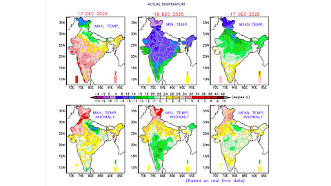
On December 17, maximum temperatures across most of the country were at least 1°C above normal. The highest anomalies of 3°C or more were recorded across large parts of north-west India, with areas of northern Rajasthan, Punjab, Himachal Pradesh, Jammu and Kashmir and Ladakh experiencing departures of up to 5°C above average.
Minimum temperatures were also higher than normal across much of northern, north-western and parts of central and eastern India. These above-normal daytime (maximum) and night-time temperatures (minimum), particularly in north-west India, have persisted on many days over recent weeks.
At the same time, parts of north-west India and many regions in central and southern India have experienced anomalous cold-wave conditions on several days during the past few weeks. Overall, the trend has been towards warmer conditions in northern India and relatively colder conditions in central and southern regions.
Rainfall has been limited across most of the country since early November, according to weekly data from the India Meteorological Department (IMD). With the exception of some southern states during certain weeks, most regions have seen little precipitation.
After November 5, rainfall has been largely absent across the country, apart from intermittent spells in a few southern states, the India Meteorological Department’s weekly data shows. Many states and Union Territories in north-west India, like Uttarakhand, Haryana, Chandigarh, Delhi, Punjab, Himachal Pradesh and Jammu and Kashmir, have recorded rainfall deficits since mid-October.
Western disturbances, carried into the region by the subtropical westerly jet stream from November onwards, are the primary source of winter snowfall in the western Himalayas and bring occasional rain to the north-western plains during the post-monsoon season. These extra-tropical storms typically draw moisture from the Mediterranean, Caspian and Black seas before travelling across Iran, Afghanistan and Pakistan into India.
Between October 15 and December 17, 2025, 12 western disturbances affected India, according to IMD data analysed by Down To Earth. Two were active between October 15 and 31, five occurred in November, and six between December 1 and 17. Most of these systems were classified as “feeble” by the IMD, particularly in the lower and upper levels of the atmosphere.
The weaker western disturbances — especially the most recent system that became active around December 12 — brought some moisture and cloud cover to north-west India. However, this has largely contributed to the build-up of smog across the region, leading to a sharp rise in air quality index levels.
The IMD also highlighted the presence of subtropical westerly jet stream winds over India at a height of about 12.6 kilometres above mean sea level, with wind speeds ranging from 95 knots (176 km per hour) to 120 knots (222 kmph) since December 7.
On December 7, the jet stream was active over northern India. The following day, its activity shifted towards north-east India. On December 9, the IMD indicated that the winds had returned to northern India, before shifting again to the north-east on December 10, where they remained until December 13. On December 14, the jet stream shifted back over north-west India, where it continued to flow until December 17.
While the relationship between the activity of the subtropical westerly jet stream and regional weather impacts remains unclear in the IMD data, the agency has identified it as one of the factors influencing weather patterns in parts of India.
Typically, the jet stream is most active over north-west India during winter, making its repeated displacement towards the north-east this season unusual. Meteorologists say this could be one reason for the reduced activity of western disturbances over north-west India, although further scientific investigation is needed.
A stronger western disturbance is forecast to affect India in the coming week, but its potential impact on weather conditions, especially in north-west India, and whether it will help disperse smog levels remains uncertain.