
Subscribe


The decision came almost as an afterthought—but at least it came. On December 29, 2025, the Supreme Court of India stayed its own judgement, delivered barely a month earlier, which had accepted a “uniform definition” of the Aravalli hills and ranges. These are the world’s oldest surviving fold mountains, some 2.5 billion years old, whose weathered remnants now stretch nearly 700 km across Gujarat, Rajasthan, Haryana and Delhi.
Under the definition, the Aravalli “hills” were described as landforms in 34 designated districts with a minimum elevation of 100 metres above the local relief or surrounding terrain, including supporting slopes and connected features. A “range” would be recognised where two or more such hills lay within 500 metres of one another.
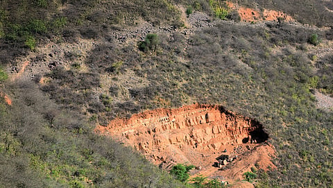
The definition, though now held in abeyance, has ignited an environmental and political firestorm, with citizens, researchers and environmental groups staging protests across the states that share the ancient range. Their chief worry is that much of the Aravallis consists of low-lying ridges and hillocks, often rising no more than 20 to 50 metres. A 100-metre cut-off would therefore strip large swathes of the range from legal protection, opening the door to unchecked mining and construction in an already beleaguered landscape. Laws such as the Environmental Protection Act, 1986, the Forest Conservation Act, 1980, a 1992 notification issued by the Union Ministry of Environment, Forest and Climate Change (MoEFCC) as well as multiple judicial interventions prohibit activities including opening new mines or expanding existing ones and infrastructure projects in the Aravallis. Yet illegal activity remains rife. Scientists warn that further degradation would be catastrophic not only for the range itself, but for entire states. “The Aravallis’ critical functions maintaining continuity as a barrier against desert sands, sustaining grassland habitats, recharging aquifers, and enabling wildlife movement—depend on the integrity of the range as a whole, not on the prominence of individual peaks. The 12 identified gaps through which Thar desert sands drift towards the northeastern plains are critical precisely because smaller hills between them have degraded or disa ppeared,” write researchers with Ashoka Trust for Research in Ecology and the Environment (ATREE) in an article, “Institutional expertise meets judicial confusion in the Aravalli hills definition case”, published on Down To Earth (DTE) website on December 30, 2025.
On December 21, MoEFCC sought to allay fears through a Press Information Bureau (PIB) release. It said, “Contrary to alarmist claims, there is no imminent threat to Aravallis’ ecology...India’s resolve is clear: the Aravallis will be safeguarded for present and future generations while balancing conservation with responsible development.” Union environment minister Bhupender Yadav went on to say the apex court-accepted definition would bring over 90 per cent of the Aravalli region under “protected area.”
However, a DTE analysis tells a different story. Using elevation data from US space agency NASA’s Shuttle Radar Topography Mission, DTE applied the Forest Survey of India’s (FSI’s) definition cited in its 2010 report—that any area with a slope of over 3 degrees would constitute for a hill—to map the Aravallis. When the definition criterion, accepted by the apex court in its November 20, 2025 judgement, was applied, the results suggested that nearly half of the Aravalli region could remain vulnerable to mining.
Small wonder, the apex court began receiving a flurry of applications from stakeholders after its November 20, 2025 judgement. Aravalli Virasat Jan Abhiyaan, a coalition of environmentalists, activists and citizens fighting to protect the mountain range, cited FSI data reported in the media and pointed out in its submission to the court that nearly 80 per cent of the Aravalli range lies across 15 districts of Rajasthan. Of the 12,081 mapped hills, 1,048—less than 9 per cent—meet the 100-metre threshold. Meaning over 90 per cent of the range, including vast stretches of ecologically critical low scrub, grasslands and ridges would therefore fall outside legal protection, leaving them vulnerable to mining, it said.
“This public dissent and criticism appear to stem from the perceived ambiguity and lack of clarity in certain terms and directives issued by this court. Consequently, there is a dire need to further probe and clarify to prevent any regulatory gaps that might undermine the ecological integrity of the Aravalli region,” the court said, while staying its November 20, 2025 order.
It has now ordered an independent high-powered committee to assess whether the 100-metre elevation criterion is scientifically sound, and to provide an impartial evaluation of the long-term impacts of applying the definition in practice. The high-powered committee is expected to identify which areas would fall within the recommended definition and which would be excluded from legal protection. The committee would also determine whether the Aravallis could face ecological harm even from sustainable or regulated mining.
The Aravallis host some of the nation’s most critical mineral deposits and, for the same reason, the hill ranges have been subjected to anthropogenic pressures, including unchecked urbanisation, resource extraction and systematic deforestation. Since 2002, the Supreme Court notes in its November 2025 judgement, it has actively addressed issues related to mining operations and the need to protect the region’s fragile ecology. To avoid conflicting rulings—since the Aravallis pass through multiple states and have no common definition—in May 2024 it directed the Centre to set up a committee to draw up a uniform definition.
The committee was helmed by MOEFCC’s joint secretary and included the secretaries from the Forest Department of each Aravalli state, representatives from Forest Survey of India (FSI) and Geological Survey of India (GSI). and members of the Supreme Court’s expert Central Empowered Committee (CEC). The committee deliberated on the rationale and feasibility of prescribing a uniform criterion for slope and elevation. Officials calculated elevation of landforms from mean sea level across each of the 34 districts in Gujarat, Rajasthan, Haryana and Delhi, identified as being in the Aravalli range by GSI. The minimum, maximum and average elevations were also calculated for each hill, notes the committee in its report, “Uniform definition of Aravalli Hills and Ranges”, submitted to the apex court in October 2025.
Though “average elevation” is a broader indicator for a hill, the Aravallis are an exception…
This article was originally published as part of the cover story Chaos in definition in the January 16-31, 2026 print edition of Down To Earth