
Subscribe

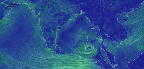
Cyclone Asani, brewing in the southern Andaman Sea, is on course to become a short-lived cyclone by May 8, 2022 and will make landfall between Visakhapatnam in Andhra Pradesh and Bhubaneswar in Odisha by May 10, the India Meteorological Department (IMD) and other sources indicated May 6.
Senior IMD officials have confirmed that the cyclone, as of now, is unlikely to cause major damages to West Bengal. There is, however, a possibility of strong winds and heavy rainfall measuring 7-11 centimetres affecting Gangetic West Bengal May 10-13.
However, another scientist from the IMD pointed out that “there are many variabilities involved, including a possibility of recurve of the cyclone path towards Bangladesh, which is also set to impact the West Bengal coast more directly”.
An IMD statement released on noon, May 6, read:
Under the influence of cyclonic circulation over south Andaman sea and neighbourhood, a low pressure area (has) formed over south Andaman sea and adjoining southeast Bay of Bengal … it is very likely to move northwestwards, intensify into a depression by May 7 evening and further into a cyclonic storm by May 8 evening.
The report further stated: “It (Asani) is very likely to continue to move northwestwards and reach west-central Bay of Bengal off north Andhra-Odisha coasts by May 10.”
On May 10, before landfall, the wind speed of the cyclone may reach “70-80 kmph (kilometres per hour) gusting to 90 kmph” over west-central and adjoining northwest and east-central Bay of Bengal.
“We, till now, could track Asani’s likely progress till May 10 and hope that a clearer picture will emerge, particularly about its post-landfall direction, tomorrow,” a senior IMD official from its cyclone division said May 6 afternoon.
The official also clarified that as of now, West Bengal is unlikely to be affected severely. The IMD projection on May 6 showed that the landfall is likely to happen around Srikakulam and will be at least 450 km away from Sagar island in West Bengal.
A senior weather scientist pointed out on social media that there is a possibility of the cyclone getting weaker before the landfall. “IMD and other agencies indicate the formation of a short-lived cyclone in the Bay of Bengal by May 8, 2022, weakening before landfall between Visakhapatnam and Bhubaneswar on May 10-11,” Roxy Koll, climate scientist associated with the Indian Institute of Tropical Meteorology, Pune and also an Intergovernmental Panel on Climate Change lead author, said.
The official IMD alert May 6 pointed out that “rain/ thunderstorm with lightning and heavy rainfall (7-11 cm) is likely over the districts of Gangetic West Bengal during May 10-13.”
West Bengal Chief Secretary HK Dwivedi, had a meeting with all district magistrates, the disaster management department as well as central agencies like IMD and National Disaster Response Force May 6 afternoon to assess preparations in view of the season’s first cyclone likely to hit within four days.
