
Subscribe

Cyclone Remal may form over the east-central Bay of Bengal in the early morning hours of May 25 and turn into a severe cyclone by the morning of May 26. The storm could also display some unpredictable characteristics, especially regarding its track and landfall, which would keep the India Meteorological Department (IMD) and the concerned state government administrations on their toes.
The IMD, in its latest cyclone update, indicated that the low pressure area formed in the south Bay of Bengal may intensify into a depression (wind speeds of 40-50 kilometres per hour) on the morning of May 24. It may further strengthen into a deep depression (winds speeds of 50-60 km/hr) on the same day and a cyclone (wind speeds of 60-70 km/hr) the following morning, moving mostly in a north eastern direction.
After Cyclone Remal forms, it may be turn northwards, gain more moisture and wind speeds and reach the West Bengal and Bangladesh coasts as a severe cyclone (wind speeds of upto 120 km/hr), according to IMD.
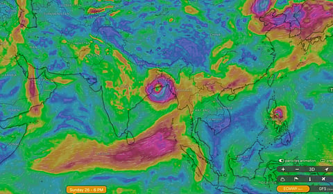
The weather analysis and visualisation platform Windy.com shows two different tracks for Cyclone Remal based on different datasets.
Using weather and climate modelling data from the European Centre for Medium-Range Weather Forecasts (ECMWF), Windy shows that the cyclonic system would be weak, take a northerly route and make landfall along the West Bengal coast, directly hitting the extremely vulnerable Sundarbans delta in the late evening hours of May 26.
A screengrab from Windy.com showing the possible landfall of Remal in Odisha.
On the other hand, when Windy uses data from the United States (US) Global Forecasting System (GFS), the cyclone seems to be taking a sharp turn towards the west and crossing the Odisha coast between Puri and Paradip on the morning of May 26.
The US Navy’s Joint Typhoon Warning Centre (JTWC), in its latest alert, highlighted the warm sea surface temperatures (30-31°C) in the path of the cyclonic system and moderate vertical wind shear, both conducive conditions for the formation of a cyclone. The JTWC does not indicate the exact track of the cyclone or provide any information about the projected wind speeds of cyclone Remal as of now.
“So far, forecast models have offered divergent predictions regarding Cyclone Remal’s path and intensity,” says The Weather Channel (TWC) in its latest post about the cyclone.
TWC further states that “The Global Forecast System (GFS) anticipates a potential escalation into a Severe Cyclonic Storm (SCS) or Very Severe Cyclonic Storm (VSCS) as it heads northwestwards towards eastern India.”
The ECMWF though “foresees a weaker system, possibly remaining a depression due to upper cold air flows, and charting a northward trajectory towards Bangladesh or northeastern India”, according to TWC.
Recent tropical cyclones in all ocean basins have shown such unpredictable characteristics which warrant better early warning systems to inform vulnerable populations in time.
The IMD has issued heavy rainfall alerts for West Bengal, Odisha, Mizoram, Tripura and south Manipur for May 26 and May 27.
All national and international weather agencies, especially the IMD, and the state administrations of Odisha, West Bengal and northeastern states of Mizoram, Manipur and Tripura would be on alert and watching the cyclonic system quite closely over the next two days as it makes landfall.