
The Kashmir valley owes much of its fortune to the plateau-like landforms that remain tucked away in the folds of the surrounding mountains, particularly the Pir Panjal range of the Himalayas that borders the valley on the southwest.
Known as karewa, these plateaus are 13,000-18,000 metre-thick deposits of alluvial soil and sediments like sandstone and mudstone. This makes them ideal for cultivation of saffron, almonds, apples and several other cash crops.
Kashmir saffron, which received a Geographical Indication (GI) tag in 2020 for its longer and thicker stigmas, deep-red colour, high aroma and bitter flavour, is grown on these karewas.
The fertility of these patches is believed to be the result of their long history of formation. When formed during the Pleistocene period (2.6 million years to 11,700 years ago), the Pir Panjal range blocked the natural drainage in the region and formed a lake spanning 5,000 sq km (roughly three times the size of Delhi).
Over the next few centuries, the water receded, making way for the valley and the formation of the karewas between the mountains. Today, the karewa sediments not only hold fossils and remnants of many human civilisations and habitations, but are also the most fertile spots in the valley.
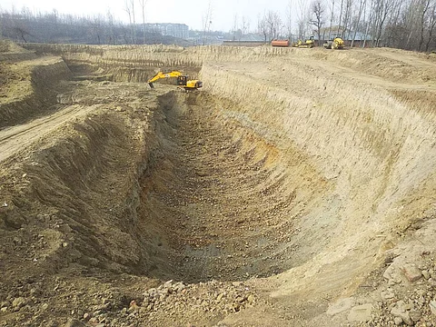
Despite its agricultural and archaeological importance, karewas are now being excavated to be used in construction. Between 1995 and 2005, massive portions of karewas in Pulwama, Budgam and Baramulla districts were razed to the ground for clay for the 125-km-long Qazigund-Baramulla rail line.
The Srinagar airport is built on the Damodar karewa in Budgam. The most recent violation took place on December 6, 2021, when the Baramulla deputy commissioner gave consent for the excavation of karewas around Pattan village and use the clay for the construction of the Srinagar ring road. Two other karewas—in Pulwama and Budgam districts—are also being excavated for the 58-km-long project.
Permanent loss
Access to large amounts of soil for development projects is difficult in the valley because of its topography and physiology. At the highest elevation are mountain ranges that are predominantly made up of hard rocks. At the lowest point lies the valley, where the groundwater table is extremely close to the surface (6-9 m). Karewas, as a result, are an easy target due to their soil thickness.
Each karewa runs for several kilometres. While most of the patches are owned by individuals who use them for farming, some belong to the government; these are locally called kahcharai and are used for grazing.
“We have failed to understand why the government is using such fertile soil for filling at construction sites. Most households in the district depend on the karewas for their livelihood,” says Hamid Rather, a social activist and resident of Pattan, adding that once destroyed, the karewas can never be restored.
Rather says dust from the mining of karewas also settles in low-lying areas where people live. Constant movement of diesel-guzzling trucks also causes pollution. “Almost every household has people suffering from respiratory problems,” he says.
Residents allege that the government’s decision to allow clay mining is illegal. The Jammu and Kashmir Land Revenue Act, 1996, says the topographic shape of a karewa or hill cannot be changed in the valley.
But clay mining often razes the highland to the ground and changes the entire topography of the place. The residents allege that the project also violates the Jammu and Kashmir Minor Mineral (Storage, Transportation of Minerals and Prevention of Illegal Mining) Rules, 2016.
“The panchayat needs to give consent for minor mineral mining. The order has conveniently bypassed this,” says Rather. The December 6, 2021, order, accessed by Down to Earth, grants permission to the lifting of clay, a minor mineral, from Pattan after consent from land owners.
Worthy alternative
The destruction of the karewas has also led to the enormous accumulation of silt in the Jhelum river, which runs parallel to the Pir Panjal, and its 42-km-long flood spill channel that runs between Padshahi Bagh on the outskirts of Srinagar and Wular lake in north Kashmir through Hokersar wetland reserve.
The flood spill channel was created in the 1920s to divert the flood discharge of the Jhelum to Wular lake and thereby protect Srinagar from getting flooded.
Ajaz Rasool, environmentalist and hydraulic engineer in Srinagar, explains that siltation occurs due to degradation of catchment areas, which is caused by deforestation and changes in land use, such as clay mining.
This has reduced the capacity of the flood spill channel from 481,440 litres of water per second to 169,920 litres per second. As a result, the capital city experienced massive floods in 2014, after a break of almost nine decades.
“The government should immediately desilt the Wular lake and its flood plain channel and the muck should be used for developmental projects,” says Rasool.
Pattan residents say the government should notify karewas as archaeological sites to promote tourism. “Multiple players across villages have an interest in them. We are trying to get them on board to get karewas legal protection,” says Rather.
This was first published in the 16-28 February edition of Down To Earth