
Subscribe

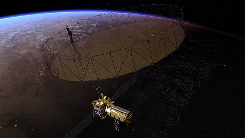
A collaboration between the United States’ National Aeronautics and Space Administration (NASA) and the Indian Space Research Organisation (ISRO) is set to revolutionise Earth observation and disaster preparedness. The highly anticipated NISAR (NASA-ISRO Synthetic Aperture Radar) satellite will track changes not only to Earth’s surface but also to ice sheets, glaciers, sea ice and vegetation, measuring shifts with precision down to “fractions of an inch”.
NISAR’s cutting-edge technology aims to deepen our understanding of dynamic Earth processes, measuring the motion of nearly all of the planet’s land and ice-covered surfaces every 12 days. The satellite will observe movements from earthquakes, ice sheet movements, landslides and volcanic activity, track changes in forests, wetlands and farmland and even check infrastructure stability.
The mission is slated to be launched early next year from Satish Dhawan Space Centre in Andhra Pradesh, India. The satellite will be launched into low Earth orbit using ISRO’s Geosynchronous Satellite Launch Vehicle Mark II rocket.
NISAR uses two advanced radar systems: An L-band radar from NASA’s Jet Propulsion Laboratory and an S-band radar from ISRO, making it the first satellite to carry both. These radars work day and night, even through clouds, unlike traditional optical instruments.
The L-band radar can also see through dense vegetation to measure ground motion, which will be particularly helpful in monitoring areas around volcanoes or fault lines hidden by vegetation.
Combined with data from other satellites and instruments, NISAR’s measurements will give a clearer view of Earth’s surface movement, both horizontally and vertically. This information will help scientists understand the mechanics of Earth’s crust and identify areas prone to earthquakes and volcanic eruptions.
The information could also help detect damage to levees or early signs of landslides. NISAR’s data collection rate will provide researchers with a more complete picture of how the planet’s surface changes over time.
“This kind of regular observation allows us to look at how Earth’s surface moves across nearly the entire planet,” Cathleen Jones, NISAR’s applications lead at NASA’s Jet Propulsion Laboratory (JPL), said in a statement. By tracking subtle horizontal and vertical movements, the satellite will allow researchers to monitor geological shifts that may precede earthquakes, volcanic eruptions and landslides.
The satellite will not predict earthquakes but will help identify areas most susceptible to seismic activity. The data will help researchers see which parts of a fault line are moving slowly without causing earthquakes and which areas are stuck and might suddenly shift.
In well-studied places like California, NISAR can help focus on regions that could lead to an earthquake. In less monitored parts of the world, it could reveal new earthquake-prone areas. When an earthquake does happen, the data will help scientists understand how the fault moved.
This continuous monitoring could be particularly valuable in regions such as the Himalayas, where seismic risks are significant. “The area has produced great magnitude earthquakes in the past and NISAR will give us unprecedented information on the seismic hazards of the Himalaya,” said Sreejith K M, ISRO’s Earth science lead for the project.
The NISAR mission will also benefit researchers focused on volcanic activity by helping track surface bulging or sinking caused by magma movement. This data will contribute to understanding volcanic behaviours and determining if such deformations hint at imminent eruptions.
Beyond natural phenomena, NISAR’s insights will aid in maintaining and protecting essential infrastructure. For example, resource managers could monitor long stretches of levees and aqueducts, identifying early signs of damage and targeting inspections more effectively. Instead of surveying an entire aqueduct every few years, authorities could focus on areas where the data indicates a shift, saving time and costs, Jones pointed out.
In the aftermath of disasters, such as an earthquake, NISAR’s data could rapidly identify compromised structures, especially across vast, critical regions like California’s Sacramento-San Joaquin River Delta. With over a thousand miles of levees, NISAR’s satellite monitoring could pinpoint problem areas, supporting quick, effective response and repairs.
The historic US-Indian collaboration exemplifies the potential of international partnerships in addressing global challenges. NISAR will be jointly managed, with JPL leading the US component and providing various high-tech instruments, while ISRO’s U R Rao Satellite Centre in Bengaluru handles the spacecraft bus and launch services.
In 2023, the satellite demonstrated its hardiness in a harsh, space-like environment in a thermal vacuum chamber in Bengaluru, India, for three weeks.