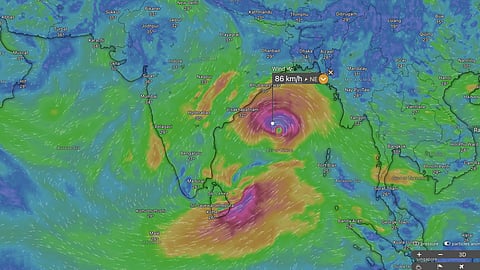


Cyclone Arnab, the first cyclonic storm of 2026 in the North Indian Ocean region, formed over the Bay of Bengal on 26 October.
The cyclone could intensify into a very severe cyclonic storm before making landfall along the Andhra Pradesh coast on 28 October.
Its remnants could move towards Uttar Pradesh and Nepal, potentially interacting with a western disturbance and bringing intense rainfall.
Another low-pressure system over the Bay of Bengal could interact with Cyclone Arnab, raising the possibility of further intensification.
The remnants of cyclone Arnab could move towards north-western India and Nepal after making landfall along the Andhra Pradesh coast, raising the possibility of an interaction with a western disturbance that could bring intense rainfall to these regions.
Cyclone Arnab (pronounced Ornab), the first cyclonic storm of 2026 in the North Indian Ocean region, formed in the early hours of October 26, according to the latest update from the India Meteorological Department (IMD). The cyclone could intensify into a severe cyclonic storm and subsequently a very severe cyclonic storm before making landfall.
The projected track suggests that the system could move north-westwards and then northwards after crossing the Andhra Pradesh coast, carrying its remnants towards Uttar Pradesh and Nepal. An interaction with a western disturbance could lead to intense precipitation over parts of northern India and Nepal.
A low-pressure area formed over the east-central and adjoining south-east Bay of Bengal on the morning of October 23. The system intensified into a depression on October 24 and a deep depression on October 25.
Cyclone Arnab was located approximately 610 kilometres south-east of Gopalpur in Odisha, 650 km east-south-east of Visakhapatnam in Andhra Pradesh and 730 km east-south-east of Kakinada, as of the latest IMD update.
The IMD forecast that the cyclone would move west-north-westwards and strengthen into a severe cyclonic storm, with wind speeds of 89-117 km/h, by the evening of October 26. It could intensify further into a very severe cyclonic storm, with wind speeds of 118-167 km/h, on October 27.
The system is then expected to move north-westwards and cross the Andhra Pradesh coast between Bapatla and Visakhapatnam before noon on October 28, with sustained wind speeds of 115-125 km/h and gusts of up to 140 km/h, according to the IMD.
Another low-pressure area, which formed on October 21 and brought rainfall to several parts of Tamil Nadu and Kerala, remained active over the south-west Bay of Bengal and adjoining southern coastal Tamil Nadu on October 26.
Data on the winds of cyclone Arnab and the low pressure area show some interaction as visualised on the weather analysis platform Windy.com. The interaction could lead to the merger of the low pressure area with cyclone Arnab and its intensification.
This could also throw up some surprises such as rapid intensification. Rapid intensification is the phenomenon through which a cyclone gains wind speeds of 55 km/h in a span of 24 hours. Scientists have observed rapid intensification in many cyclones in the North Indian Ocean region in the past few years such as cyclone Biparjoy in 2023, cyclone Tauktae in 2021 and others.
Further the track of cyclone Arnab after it crosses over to land is in a northwestward and then northward direction taking its remnant system towards Uttar Pradesh and Nepal.
A previous deep depression followed a similar track towards Uttar Pradesh and Nepal towards the end of September, bringing significant rainfall and triggering flash floods and landslides in several areas.