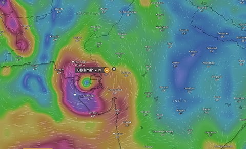

The deep depression that has been causing torrents of rain over Gujarat for the past three days is going into intensify into a tropical cyclone over the Arabian Sea on August 30, according to the India Meteorological Department (IMD). When it forms, it would be called Cyclone Asna. The reason for its formation and intensification could lie in an unusual monsoon wind system in the current season.
This would be another rare feat for the current system as the formation of depression occurred over land and the cyclone formation would happen over the sea. The deep depression was located 60 km northwest of Bhuj and 80 km northeast of Naliya in Gujarat at 8:30 am on August 29.
This is the first cyclone that has formed in August in the North Indian Ocean (NIO) region since 1981 and first in the Arabian Sea since 1976, according to cyclone data from the IMD, analysed by Down To Earth (DTE). There have been 32 previous cyclones in the NIO region in August and only four in the Arabian Sea between 1891 and 2023.
“It is likely to move west-southwestwards, emerge into northeast Arabian Sea off Kachchh and adjoining Saurashtra & Pakistan coasts and intensify into a Cyclonic Storm on 30th August. Thereafter, it would continue to move nearly west-southwestwards over northeast Arabian Sea away from Indian coast during subsequent 2 days,” says IMD in its latest press release.
The Windy weather analysis and visualisation platform, however, still shows a clear eye of the cyclone and cyclonic wind speeds with both European Centre for Medium-Range Weather Forecasts (ECMWF) and United States Global Forecasting System (GFS).
As of August 29, Gujarat has received 48 per cent excess rainfall in the current monsoon season. This figure was 17 per cent on August 26. The state has had a massive swing in rainfall of 31percentage points in a matter of three days.
The dry regions of Saurashtra and Kutch have been specifically affected by the rain and consequent floods. They were at 28 per cent excess rainfall on August 26, which jumped to 86 per cent on August 29, a drastic increase in percentage points of 58.
The reasons for the formation and intensification of the current deep depression and the other system that formed in the beginning of August over land may lie in the behaviour of the monsoon winds in the current season, apart from the moisture from the Arabian Sea and soil moisture from the lands that they have traversed in their journeys.
“For a long time, we thought a necessary prerequisite (for the formation of such land-based systems) was lots of soil moisture, so that the land could provide adequate moisture to disturbances, allowing them to intensify as they would if they were over the ocean,” Kieran Hunt, research fellow in Tropical and Himalayan Meteorology, University of Reading, United Kingdom, told DTE.
“We’re no longer sure this is the case, and in fact, what seems to matter is the configuration of the large-scale winds. This year, the monsoon circulation has been quite unusual,” he added.
Usually, the curving of the monsoon trough at its eastern end provides the necessary conditions such as vorticity, which is a twisting motion in the atmosphere, for the seed to form and grown into monsoon depressions. This normally happens in the Bay of Bengal, according to Hunt.
In the case of the depression that originated in West Bengal around August 1 and dissipated over Rajasthan around August 6, Hunt explained that “at that time the trough was shifted slightly westward, and so that depression also ended up forming further west than usual (i.e. over land).”
The case of the deep depression and possible land cyclone over Gujarat is quite different, as per Hunt.
“For a while, the monsoon has had a break-like circulation. Although it has managed to maintain enough rainfall that it is not officially a break. This led to strong easterly winds over southern India, which are cyclonic and good for growing Low Pressure systems (LPS)/depressions along their northern edge,” said Hunt.
These easterly winds combined with a strong monsoonal event known as the Boreal Summer Intra-seasonal Oscillation (BSISO) wherein heat gets transferred from the Indian Ocean to the Western Pacific Ocean to form the LPS. The LPS eventually intensified into the deep depression which has caused exceptionally heavy rainfall over Gujarat that have led to floods, according to Hunt.
“I’m not 100 per cent sure why this happened, but my guess from looking at the charts is that the atmosphere was quite unstable there, and so when the LPS arrived it triggered deep and widespread convective storms, which in turn act as fuel for the depression,” said Hunt.